FIELD REPORT ON THE ARCHAEOLOGICAL EXCAVATIONS AT USHARAL-ILIBALYK, KAZAKHSTAN IN 2019


![]()

Southwestern Baptist Theological Seminary, USA
FIELD REPORT ON THE
ARCHAEOLOGICAL EXCAVATIONS AT USHARAL-ILIBALYK, KAZAKHSTAN IN 2019
(ABBRIDGED EDITION)
Almaty 2019
Under supervision of: Prof. Christoph Baumer
LIST OF EXCAVATION TEAM LEADERS
Dr. Dmitriy Voyakin
Director General, Archaeological Expertise, LLP
Dr. Steven Gilbert
Assistant Field Director Senior Research Fellow, Department of Nestorian Studies, Academy of Sciences, Republic of Kazakhstan
Denis Sorokin Archaeologist
Head of project execution department, Archaeological Expertise, LLP0
Introduction
This 2019 field season of the international archaeological excavations at Usharal-Ilibalyk in the Republic of Kazakhstan marked the beginning of the fourth year of cooperation between Archaeological Expertise, LLC (Kazakhstan) and the Tandy Institute for Archaeology (USA) in concert with the financial sponsorship of the Society for the Exploration of Eurasia along with contributions from the Archaeological Institute of the Academy of Sciences of the Republic of Kazakhstan. The findings and investigations of the medieval city of Ilibalyk—as first identified and located by Karl Baipakov (Baipakov, 1986) have demonstrated significant progress in our understanding of both this city along the Silk Road as well as the community of Church of the East Christians that inhabited it between the 12th through 14th centuries.
To date, since the initial discovery of a gravestone with a cross with Turkic writing in Syriac script in 2014 (see Baumer, 2016 a, 286.), a total of 34 gravestones (three with additional inscriptions) have been found by our excavation team. These findings alone provide us with an understanding of some of the Christians that inhabited the area, including the identification of clergy and people with namesakes connected to the saints of the Church of the East (Nestorian). However, further excavations in the shahristan area, (which has also revealed a monumental bathhouse (Baipakov, 2019,) , the rabat (surrounding neighborhood) and particularly a large cemetery in conjunction with the gravestones, referred to in our context as kayraks, are providing a clearer picture of this community; some of their burial customs; and linkages fostered by their location along the trade routes which flourished during the latter half of the Middle Ages during the Karakhanid era and Chagatai Khanate. This season’s findings now also have revealed an even stronger link to global Christendom, as will be explained subsequently.
Excavations focused on the cemetery once more in a continuation of the 2018 season, in which 33 graves were excavated. This season’s excavators investigated an additional 45 graves, this time containing a majority of adults as opposed to only 2 adult graves found 2018. Adult graves were found at deeper levels, thus providing an explanation for the large number of juvenile graves at shallower depths, although in some instances children’s graves were also at similar levels to those of adults. This season also yielded a far better understanding of grave construction and types as for the first time, excavators could identify the mudbrick used in the majority of cases. This was due, in part, to providential rainfall, which helped excavators better discern the brick when the soil became damp. As a result, a water sprayer was employed to assist with visibility in the brownish-gray soil.
This technique allowed our team to identify a total of 4 possible grave construction types of only one section (Area C) of the overall cemetery whose boundaries are slightly clearer despite our goal to discern the entirety of the cemetery’s limits. In addition, there are certain sections of Area C which we are rather certain will yield more graves but for which lack of time prohibited further investigation.
Preliminary field forensic investigations conducted on the bodies themselves have also provided a significant amount of information. While the preliminary results here are limited by our lack of expertise in forensic pathology (laboratory investigations are slated for the future),
we were able to make basic observations concerning sex (of adult bodies), age, body placement, and grave goods. Soil, C-14, and DNA samples were taken for further investigation. While our budget limitations are proving a hindrance particular pertaining to our lab samples which could provide us with further information, general observations are provided in this preliminary report concerning the first excavation of a Church of the East cemetery in over 130 years. This is particularly true concerning radiocarbon dating.
The 2019 excavations were conducted in two phases. Phase 1 involved the preparation and clearing of the field. Since the cemetery resides in a protected state forest, which during the bulk of the 20th century served collective farmland during the Soviet period, we are required to backfill this area following each season’s dig. This phase occurred between June 17 and June 30. These preparations included revealing the previous year’s excavation units, particularly Unit 3 and Unit 5 which had revealed graves with mudbrick construction which needed to be investigated and had been protected using Geotech fabric. Preparations also sought to provide a clear picture of the site for the arrival of participants of the Salzburg International Conference. This group of international scholars saw firsthand some of the newly revealed graves which were discovered along with some of the preliminary finds that additional clearing provided which will be described below.
Phase 2, conducted July 1 – 31, involved the bulk of the grave excavations. A team of almost 50 workers comprised of both Kazakhstani and international archaeologists, local and international volunteers, experienced technical diggers, and local villagers worked together in accomplishing our research goals. As with any cross-cultural endeavor, challenges of communication and approaches to the work existed, yet overall, the friendship and relationships fostered along with the research findings outweighed any differences encountered.
This preliminary report will provide our team’s research objectives; detail specifications on equipment and processes followed; and provide descriptions of field excavations and artifact finds. A section will also be devoted to our analysis of various grave construction types and our preliminary field forensic analysis as well as provide preliminary data on some laboratory analysis. Concluding interpretations will also be provided along with additional research questions raised which warrant further investigation.
The research objectives for the 2019 Usharal-Ilibalyk excavation were as follows:
- Conduct further geo-archaeological exploration to identify and recover the monuments and anthropological forensic evidence of the site of Usharal-Ilibalyk through continued examination of the identified Church of the East (Nestorian) cemetery and, perhaps any revealed, related architecture.
- Further identify and define the borders, topography, and layout of the Christian necropolis.
- Analyze the stratigraphy and chronology of the cemetery and any surrounding features.
- tudy the artifacts, faunal, and flora remains in the stratigraphy and while assessing any coins as they are uncovered and where possible obtain carbon samples for future radiocarbon (C-14) analysis.
- Manpower permitting, conduct additional excavations in the citadel area to further determine lifestyle and possible religious affiliation of the elite population of the city.
- Prepare a scientific report of the findings and two publications in Russian and English languages, with the eventual goal of providing a summary a report of the findings also in Kazakh.
Summary of Procedures and Methodologies Undertaken in Fulfillment of 2019 Objectives
Based upon our team’s research design which received official approval and permissions from the proper legal entities, both local and national, of the Republic of Kazakhstan, preliminary excavations began June 17 and continued through June 30 to prepare the Area C of Field IV for extensive excavations of the graves in the cemetery, as demarcated during the 2018 season.
Phase 1 involved the clearing of previous backfill of an area approximately 45 N/S x 30 E/W m for an area 1350 m2 which comprised the layout of our designated Area C, whose initial excavations actually began in 2017. Geotech fabric which had been laid in Units 3 and 5 were uncovered where at least 4 graves had been located but left unexcavated due to time limitations the previous year. Once this was accomplished and the baulks of these two units shaved and cleared, additional lowering of the entire area of Area C with a crew of workers utilizing hand shovels commenced.
Since the soil was backfill from the previous seasons, none of the sparse cultural material found during this phase was to be considered helpful for diagnostic purposes. None of the soil was sifted. However, once excavators reached the final level of the 2018 season, further passes were conducted with the intent of exposing additional graves and/or new cultural material.
It was during this additional clearing that a large number of grave shafts were located, particularly in the northern sector of Area C which were eventually designated Unit 7 with subdivisions A through D (See Re-organization section which describes the re-designations of Area C). As mentioned above, rain overnight enhanced the ability to see the mudbrick construction and grave shafts in contrast with the surrounding soil of a number of the graves which led to the eventual utilization of a water sprayer throughout the remainder of the excavation.
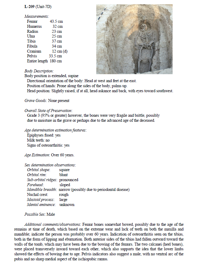
The additional clearing and lowering of Area C resulted in some additional cultural finds in the cemetery. First, an in situ gravestone (Kairak 1, Locus 062) was found at a depth of 597.583 m asl (above sea level) on the northeast side of Area C in what eventually was designated Unit 7D. This stone was associated with a grave chamber, (L-063), which was eventually excavated during Phase 2.
The second significant find of note occurred when a metallic cross was found in the far southern baulk of Area C near Unit 3 and very close to what eventually became U-9C. This equilateral copper or bronze cross of the croix patee style measured approximately 5 x 5 cm at a depth of 597.384 m asl. It was found with the use of a metal detector during this initial clearing phase and removed, labeled and bagged (see description in Special Artifacts section and Appendix).
Archaeological Expertise provided a technician who used a metal detector scanning the entirety of Area C following initial clearing. Several metal objects were discovered with metal detection during this initial phase of excavations, but most were found outside Area C and on the surface of our designated Field IV (see Conner, 1998 for utilization of metal detectors in controlled contexts). These finds, which can be found in the Appendix, included coins of the Karakhanid and Mongolian eras, bovine tackle, and various personal items, including a possible opium or tobacco pipe of Chinese origin from the 17th-18th century which provides possible evidence pertaining to the presence of an unexcavated fortress located just 2 – 3 km to the west of the Ilibalyk site. Since all the these finds, with the exception of the metal cross, were found on the surface and ploughzone, they could not be used for diagnostic or dating purposes other than for the most general of contexts. The coin findings will contribute to a further understanding of the occupational date ranges for Ilibalyk as a whole which have previously been published with coin hordes found in the area in years past (Petrov, 2014). The newly found coins have yet to be examined by a numismatist.
Phase 2 (July 1 – 31) commenced with the plan to focus on excavating the newly revealed graves—whose number and concentration had dramatically increased due to Phase 1— as well as continuing to excavate Units 3 and 5 in an effort to determine where the sterile layer of the cemetery might be or if there was any evidence of vertical phasing. In addition, due to the finds of the in situ gravestone (L-062) it was determined to expand Area C to the east by leveling a 2.7 m (E/W) x 37.8 (N/S) m area that was initially labeled L-106 whose designation was eventually absorbed into Units 7D and 8B. Two additional test trenches were also dug (Units
10 and 11); each 5 meters wide with one proceeding from the southwest edge (U-10) of Area C for 45 meters and the other proceeding northeast (U-11) for 27.5 meters. The purpose of these trenches was to try and obtain an estimate of the northern and southern boundaries of the cemetery.
The large number of newly exposed graves limited our team’s ability to do field surveys in an attempt to locate possible architecture in Field IV, thus this aspect of our research design is unfortunately delayed. However, excavations from 2016 and 2017 revealed structures both to the east and west of current excavations. The 2017 structures (a possible metal production kiln and a possible small domicile (?) located in Area B) are currently interpreted as structures built on top of the cemetery at a later period following the discontinuation of internments in the cemetery, possibly by a later culture. However, this interpretation may need revision due to the fact that it was made prior to the discovery of graves in Field IV and based on our fresh understanding of the cemetery, a re-examination of the evidence from Area B is in order.
The structure found in 2016 lay to the southeast of Area C by 100 - 150 meters. Based on the cultural material found in and around this small structure, which contained a small mudbrick courtyard, this area was occupied for a period of time, possibly mid-13th century based on a radiocarbon sample from a nearby trash pit that dated to that period. These structures together with further field surveys could reveal architecture with connections to the cemetery itself, or aid in interpreting its boundaries.
Chronological phasing is another important aspect that our Phase 2 excavations hoped to reveal. The 2018, 31 of 33 graves excavated were juveniles. If the burials at Ilibalyk are consistent with those in Bishkek excavated by Pantusov in 1886, then this is to be expected (see Kolchenko, 2018, 48-103.). In those contexts, children’s graves were found at shallower levels than those of adults. Genuine vertical phasing of the Ilibalyk cemetery could only be proven if graves were found on top of each other, preferably adult above adult, or if there was evidence of grave disturbance of earlier burials. As reported below, there is vitually no vertical phasing evidence and, if so, involved only infant burials above adults in the similar vicinity, although the evidence even seems to indicate that care was taken to insure that did not happen. While our findings confirm those of Pantusov concerning children buried at shallower levels, we still lack significant evidence for vertical phasing.
However, it is important to note that the passage of time with cemeteries can also have a horizontal component. All cemeteries have a beginning. As time goes by, memory and grave markers serve as directives of where later burials are possible or permissible given the conditions and limitations of a burial plot. If burials occur around a religious or ecclesiastical structure, with the first burials closest to the structure, then subsequent burials later in time would radiate outward or in a direction away from that structure. If there is no structure, then the same principle might be employed in relation to the initial interments. Since we do not yet have the advantage of knowing if there is even an ecclesiastical structure, such as a church or funerary chapel, in the area of the cemetery at Ilibalyk, we merely have the ability to inspect the grave constructions themselves. As will be shown below, there is very slight evidence of horizonal phasing in only one example. Yet, this evidence, however slight, may provide us in the future with the ability to test this hypothesis.
Further excavations in the citadel and sharistan areas of the city, which lay south of the graveyard by almost 2 kilometers were also not possible in 2019. However, the recent report provided by the late Professor Karl Baipakov and Iliyar Kamaldinvo from their 2018 excavations of this region—which further exposed a monumental bath house (hamam) and examined the inner walls containing a cache of valuable jewelry—provided us with a significant contribution in providing a context for the later finds of the grave in Locus-089 (see Special Artifacts section below).
The recent discoveries at Usharal-Ilibalyk mark the first modern, controlled excavations of a Church of the East cemetery in Central Asia. They are also the first excavations of a Church of the East cemetery of this size in 133 years. These findings are beginning to attract attention both within Kazakhstan as well as internationally. Ultimately, this history belongs to the people of Kazakhstan. For that reason, it is the goal of the international team of archaeologists and researchers to begin to make this information available in multiple languages of Central Asia and to also point to the major contribution provided by Kazakhstani citizens that have both made this project possible as well as provided the bulk examination and research.
For the past two seasons (2018-19) the team’s work has focused exclusively on what we have designated as Area C, within Field IV, which was actually contained within an even larger Field III, all north and outside the city walls of the main sharistan and rabad of Ilibalyk. Even in 2017, excavations occurred Area C and this was the location where the largest number of gravestones (kayraks), 26, have been found. Since each season backfilling must occur, we are faced with various challenges of continuity with our excavations. In addition, the multi-national nature of our team with varied approaches and training has, at times, caused confusion as to methodology, particularly in field organization.
These factors combined to create confusion as to unit and loci designations. In 2019, it was decided to re-organize Area C to simplify and provide clarity to our descriptions and graphics of this part of the cemetery. Almost all loci designations were carried over from previous seasons with the exception of a few cases of some loci receiving two numbers (as seen in Unit 3). Unit numbers 1 through 6 also remained the same. However, 2018’s units 7 – 20 were dropped and the remainder of our exposed Area C were given designations Units 7 (A,B,C,D); 8 (A,B); 9 (A,B,C). This divided the cemetery in sub-sections running north to south and east to west in a modified grid system. Loci numbers were distributed consecutively throughout Area C regardless of unit number.
In addition, the entire size of Area C was originally a rectangular 38 (E/W) x 52 (N/S) meters and this area was cleared of topsoil in an attempt to discern graves in 2017. While more gravestones were found, no graves were revealed. Three units were excavated at that time. One on the far southern edge, Unit 1, where one possible gravestone was found; Unit 2— in the central section of the Area C in which two gravestones were revealed, including one with a written inscription (The Yoshmid Stone)— and Unit 3, near the location of another gravestone that produced a trash pit and other manifestations on the soil.
In 2018, excavations continued in Area C, but the exposed section for excavation included a size of 890 m2 of exposed area as opposed to the previous season’s 1830 m2. As our report from 2018 explains, it was here beginning at depths of 597.899 m asl that we found initial human remains and exposed 33 graves in addition to finding 8 gravestones and 3 fired brick grave markers. The previous season’s Units 1, 2, and 3 were dropped and the new units were created based on the exposure of human remains. Thus, the 2018-unit designations are the baseline of units that proceeded forward in our excavations with units 1, 2, and 3, not the same as those of the previous year and excavated to significantly deeper levels.
The 2019 excavations returned and re-exposed this trapezoidal section of Area C, which was then also cleared to even lower levels. The previous season’s units, preserved with Geotech fabric, were also exposed, although units 1, 2, 4, and 6 were not re-examined due to time and labor limitations. As mentioned above, a large number of graves were found, particularly in Unit 7, but also within Units 8 and 9 as well. This reorganization will now assist our ability to better track both the graves which have been excavated as well as those which have not, but which provided information regarding the number of interments and size of graves.
The Usharal-Ilibalyk 2019 dig team contained no trained forensic pathologists. However, an attempt was made based on forensic guidelines to analyze the skeletal remains found in the graveyard while in the field. An osteological worksheet (see appendix) was prepared for each field archaeologist for the purpose of recording basic features of the human remains found. This included noting the type of burial (primary, secondary, individual, multiple); measurements of the major bones; descriptions of the body position, direction, hand and head position; overall state of preservation; making simple, general age determinations (stillborn, newborn, juvenile, adult); examination of skull features to possibly discern sex in adult remains; and whether grave goods were present. If the remains were that of a child or infant, no attempt at discerning sex was made. Photos of the skeletal remains included closes ups of the cranium, maxilla/mandible/teeth, pelvic girdle, and any other special features related to the body or grave.
Any determinations in the field and contained in this report should not be considered the final conclusion concerning the human remains. Each skeleton, following recordation, was packed separately according to their axial and appendicular arrangements, both right and left, with the cranium, maxilla and mandible apart from these in aluminum foil with individual labels and then the entire skeleton was carefully boxed and labeled. The hope is that laboratory forensics will provide a wealth of information that can enhance, supplement, and where necessary, correct the field forensic analysis.
Each skeleton is listed in this forensic analysis numerically according to loci number. To understand the context of these remains archaeologically, we refer the reader to the Unit and Loci Descriptions. See also the grave comparison worksheet in the appendix.
Special Artifact Descriptions
Cultural material was found throughout Area C, which designates only a part of the cemetery. Apart from the skeletal remains, animal bone and pottery fragments penetrate all areas of the soil. It should be noted, however, that pottery and bone diminished considerably at lower depths and were often limited to being intentionally placed in the grave as grave goods, or as temper fill from the mudbricks used in grave construction. As explained in the context of the 2018 excavations, certain pottery and bones along with the presence of ash pits, appear to be in conjunction with funerary meals.
The following artifact descriptions are only those considered to be exceptional finds based on context, uniqueness, or importance in relation to the human remains. In addition, as pointed out in the introduction, items found on the surface levels via the use of a metal detector are not included in this section, with the exception of the metal cross described below. A complete listing of artifacts, including those in this section can be found in the Appendix.
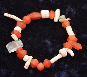
The majority of graves excavated to date in Area C contain no grave goods. Of those that do 13% are from juvenile graves in the form of simple jewelry. The most predominate form of jewelry are micro-sized glass paste beads probably worn as jewelry, however, there are instances of freshwater pearl earrings, and a finger ring (see L-026 and L-043 in 2018). Excavators have only found three graves among the 32 adult graves (9%) excavated to date that contained jewelry. All of these are detailed below.
Some pottery sherds can also possibly be classified as grave goods, however, there is uncertainty as to whether these were intentionally placed pottery sherds at the time of burial or may actually be temper from mudbricks used to cover the graves. Therefore, the pottery finds listed below that did come from graves will be classified with special pottery finds rather than as grave goods.
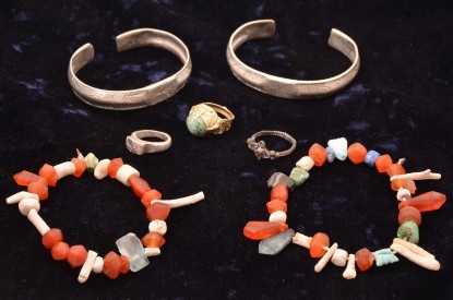
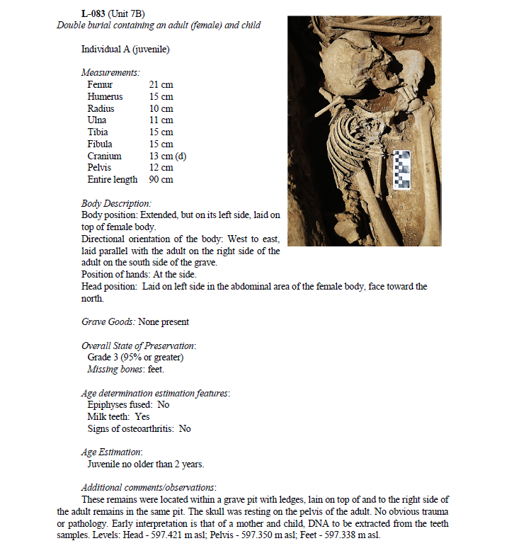
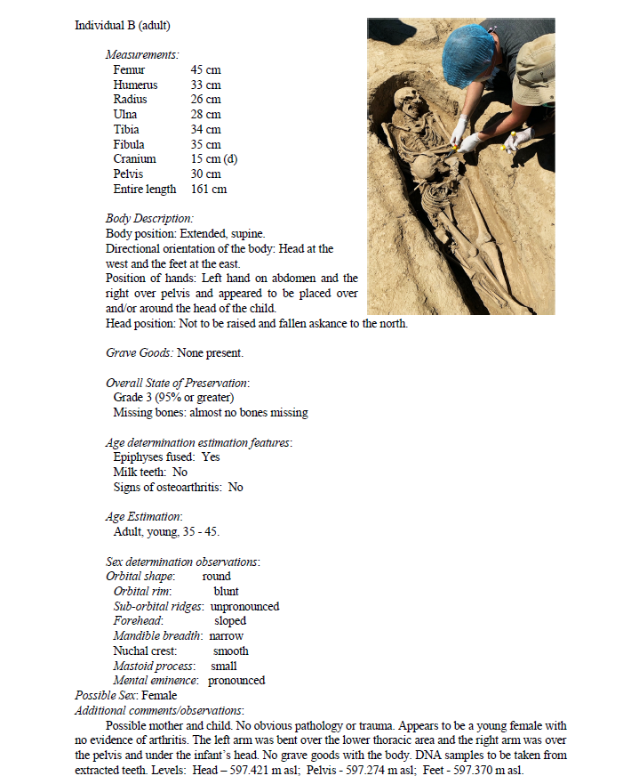
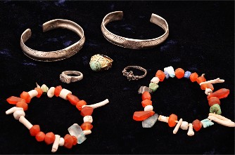
| Special Finds in L-089 | ||
| Excavations in L-089 of an adult female in U-7B whose grave lay in the northern sector of Area C, yielded some exceptional jewelry finds whose significance is determined not merely by their elite status from an economic standpoint, but also from an iconographic and religious standpoint. |
 |
|
The finds from L-089 included 4 finger rings (one a gold with a jade stone, one silver, and two other still-to-be determined metals), 2 silver bracelets, 2 beaded bracelets of semi-precious stones and glass paste, and a set of freshwater pearl earrings with copper fittings. Each piece of jewelry was found on the person’s body and the location will be described below. It should also be noted that a very small fragment of cloth was found attached on the edge of one of the silver bracelets. |
||
| Gold Ring with Green Turquoise Stone (Ib_19_C_IV_089_I005_13) | ||
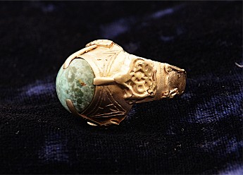 |
This gold ring was found on the middle finger of the left hand of the female remains in L-089. The dimensions of the ring are 2 cm in width x 2.8 cm in height. It weighs 7.3 grams. It has a green turquoise center stone held in place by 4 prongs two of which are 9.1 mm in length and oppose one another proceeding a quarter of the distance up the crown of the stone. The other two opposing prongs are shorter and do not actually touch the stone but appear to serve a more decorative purpose or were used to hold the embellishments of the ring’s shoulders in place. | |
The bluish-green symmetrically rounded turquoise stone is rather cloudy in appearance with severe corrosion and mottling of the stone probably due to the effect of the elements in the grave. The stone measures 12 mm in diameter. The mounting appears carefully incised with two concentric circles around its circumference. The bezel gallery contains 4 shoulders with double-lined, equilateral triangular incisions. The interior of each triangle contains 6 incised line, 3 in each corner and 3 at the midpoint of each side. This ring also has a significant amount of skilled applique along the shank of the ring. Most prominent are the embellishments on each shoulder of the ring, however, one side’s embellishments have fallen off or were corroded from the shank. This elaborate applique displays a rounded design with several intersecting lines, similar to turkic designs found in the region even today, culminating in a peak in the direction of the stone. It measures 10.6 x 9 mm. Applique embellishments of 7.7 mm can also be seen at the base of the bezel under the long prongs on each side which secure the stone. The designs have a mirror effect with curved incisions. |
||
| Along each edge shank all the way to the base of the ring’s shank are additional embellishments of raised applique which are connected with a horizontal applique along the shanks’ edges. It is possible that further embellishments were attached at the base of the ring that have since disappeared. The very base of the ring contains a small raised “knob” 2.8 mm in diameter. No written inscriptions are found anywhere on the ring. The bezel of the ring appears to have been a separate soldered attachment. The ring is in excellent condition with the exception of the condition of theturquoise stone, which has certainly lost some of its former brilliance. While most forms of turquoise are blue, this stone has a light green appearance. |
 |
|
|
||
| Silver Ring with Double Four-leaf Rosette (Ib_19_C_IV_089_I006_14) | ||
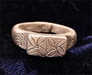 |
This silver ring was found on the fifth digit (pinky) of the female’s right hand in L-089. It is 2.3 cm from the base of the shank to the top of the solid bezel and is 2 cm in diameter from the right to left shank. The width of the rather thick shank ranges from 5.5 mm to 2.5 mm. The ring weighs 6.4 grams. On the side of each shank are a series of incised dots in rather hastily placed rows. One side has 40 dots in 7 rows, the other side has 35 to 37 dots in 7 or 8 rows. The latter appears to have been done by a quick, inexact hand, thus making identifying the number of rows and dots a bit arbitrary. The dots are incised on each shoulder of the ring which has a slight indentation leading up to the ring’s rectangular bezel. The base of the shank appears to have been sawdered together following casting, possibly indicating that the ring was sized after it was made. |
|
| The rectangular bezel (12.1 mm x 6.6 mm) is incised with two four-leaf rosettes separated by an incised centerline. In the background of each rosette are cross inscriptions of the bolnisi or croix pattée style with a series of dots which may have applied to accent the appearance of the cross. These dots appear in random numbers on each cross beam with one side possessing a total of 16 dots and the other a total of 19 dots. A ring of this type was found during the 2018 season in the cemetery in L-026, U-5, on the finger of a child between 4-6 years old, however, it did not appear to contain the incised designs that appear on this ring. The four-leaf rosette design on this ring appears to be in conjunction with the two silver bracelets found on each arm of the female remains of L-089, which possess a similar design (see below). |
||
| Silver Ring with Cruciform Floral Design (Ib_19_C_IV_089_I007_15) | ||
| This silver alloy ring of intricate design was found on the left index finger of the female remains in L-089. It is 2.6 cm from the base of the shank to the center crown. It weighs 2.8 grams. The outer shank has a slightly raised rim that is an impressed relief on the inner shank whose width is 1.2 mm. Across the entire surface of the shank, or band, there is an intricate series of raised plats that give it a braided appearance. | 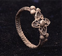 |
|
Each shoulder has a set of three beads creating a setting for the central design which is a symmetrically shaped cruciform floral design (12 x 13 mm). Each side of each petal of the floral design curls at the base, folding back on itself to connect to the petal walls. The center part of the design is similar to a flower pistil. It is unknown if the center piece at one time possessed stone settings. Given the context of this grave in conjunction with the four-leaf rosette design found on one of the rings and the 2 silver bracelets, religious symbolism for this ring cannot be ruled out. |
||
| Fragmented Silver Ring with Rhombic Bezel (Ib_19_C_IV_089_I013_20) | ||
 |
This silver alloy ring was found in the right-hand area of the female remains in L-089. It was discovered following removal of the body. The shank of the ring was fragmented into five pieces and appears to be of the same metal alloy as that of the ring with the floral design described above. The rhombic-shaped (diamond) bezel measures 8 x 8 mm and is 2 mm thick. The ring weighs 1.7 grams. The shank’s diameter cannot be determined with accuracy due to its fragmentation. | |
As with the floral-designed ring, the shank has a similar plait technique and also has matching three beads on each shoulder of the shank, although these beads are much more corroded and even appear to have been damaged by flattening. Such similarities in metal and design causes one to consider that these two rings were possibly part of a set. The main difference between these rings is the rhombic bezel on this ring which contains a series of indecipherable incisions on the surface. These incisions appear to be a series of 11 – 13 chisel marks. It may indicate a tamga design (mark of ownership or tribal affiliation) or this may have been part of a soldering technique to enhance adherence of a setting for a stone or other embellishment on top of the bezel, thus serving as a bridge for the larger setting. The ring’s damage prohibits an accurate interpretation. |
||
| Beaded Bracelet (Right Arm; Ib_19_C_IV_089_I003-11.) | ||
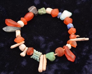 |
This bracelet of strung beads containing semi-precious stones, glass paste beads, and ocean coral fragments (most likely red coral that were bleached white with time) was found on the lower right arm of the female remains in L-089. With a possible exception of one bead containing a fiber fragment (see below), the string used to connect the beads was completely deteriorated. The bracelet in the photograph is strung in the order as the beads were found in the grave. It should be noted, however, that a few unassigned beads were found, meaning the excavators could not determine to which bracelet those beads belonged. This bracelet contained at least 30 beads. Twelve of the beads are carnelian stones, 7 of which are rounded, disk-shaped cylinders with 12 facets; one is an elongated smooth cylinder, and one is a rounded, smooth bead. Three are elongated, teardrop-shaped stones with 11 facets which descend into a widened point. One of these stones has been broken and only the shaft remains. |
|
|
||
| Two of the beads with facets made of a dark blue stone, probably lapis lapsuli, with white splotches. One is worn and corroded (6.4 x 3.8 mm), but originally was probably the same size as its counterpart which is rounded with 12 facets (6.8 x 5.5mm). Another rounded bead with a light-green tint, possibly green turquoise, and has a flattened surface on both sides. This bead is chipped with black colored striations. It measures 10 x 8.9 mm. There is another rectangular shaped glass paste bead containing two parallel incisions on each side of the bead (10.8 x 10 x 5.1 mm). On one set of opposing sides there are sloping indentations, on the other two opposing sides there are three small symmetrical notches. | 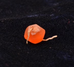 |
|
| A faded light-blue glaze probably fully enveloped the bead, but it has now faded from the elements inside the grave. One triangular shaped glass paste bead with the same type of blue glaze was also a part of the bracelet and measures (14.9 x 9.8 x 5.9 mm). It, too, is highly faded. The entire weight of the thirty beads (although the total number beads may have been more) is 21.2 grams. One multi-faceted red carnelian bead which may have been connected with this bracelet appeared to possibly contain an original fiber that bound the bracelet together. This bead was bagged separately, and future analysis may provide an answer to the type of fabric or material that was used for this process. |
||
| Beaded Bracelet (Left Arm; Ib_19_C_IV_089_I011_19) | ||
 |
This is also a bracelet of semi-precious stones, glass-paste beads and ocean coral fragments found in and around the left arm of the female remains of L-089. The 27 beads seen in the photograph are strung as they were found on the body. There may be one or two beads that were found in the grave but were unassigned, meaning excavators could not determine if the beads belonged to this bracelet or the other. |
|
This bracelet has similar stones to the right arm bracelet, with the predominate beads being carnelian stones and fragments of red coral, now bleached white. Of the 14 carnelian stones, 11 were various sized disk-shaped cylinders containing 12 facets. One is an elongated cylinder with 12 facets (15 x 8.1 x 4.4 mm). One is a rounded, smooth bead (7.9 x 3.7 mm). One is an elongated, teardrop shaped stone with 12 facets which descends into a widened point (15.8 x 6.7 mm). Ten of the beads are from red ocean coral. Four of these beads are rounded disk cylinders, 3 are branches of a coral tree that are strung horizontally along the shaft, and 3 are have the sting hole at one end, thus meant to be strung vertically in the necklace. Like the bracelet on the right arm, at least one of the coral beads contains orange-colored fragments remaining on the beads which have now bleached white. The size of the thread holes varies from 1 to 5 mm in size. This bracelet also contains a light green bead but made with glass paste as opposed to a semi- precious stone. It has a similar design as most of the carnelian beads, a twelve-faceted disk (9.2 x6.7 mm). It may have been covered with an opaque, multi-colored glaze. There is also a glass paste bead that was at one time covered entirely with a light blue glaze, but which has now almost completely worn off. This bead possesses a rectangular shape and appears to have been chipped on one side (16.2 x 10.1 x 6.1 mm). One bead in the bracelet has a triangular shape (13.7 x 9.7 x 5.9 mm) and is made of white glass paste. It was also at one time covered in a light blue glaze. The weight of the bracelet—with the possibility that some beads are missing— is 19.9 grams. |
||
| Silver Bracelet (right arm; Ib_19_C_IV_089_I010_18.) | ||
This silver bracelet with an intricate design was found on the right arm of the female remains of L-089. It is one of a matching pair found on the left arm and also similar in design to a silver ring found on the fifth digit of the female’s right hand, in that the primary design in the flattened center of the bracelet contains a four-leaf rosette design. The bracelet was cast in a mold and the design etchings appear to have been done with a free hand with no uniform stenciling, but with a similar pattern to its counterpart on the left arm. The loop of the bracelet raises slightly to a sloped peak and has a gap of 3 cm between each terminal end. The edges of the bracelet have a slightly raised ridge. |
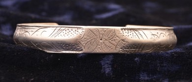 |
|
| The bracelet weighs 33.2 grams and measures 5.0 x 7.1 cm. The central design, the four-leaf rosette, appears in front of what appears to be a modified bolnisi or croix pattée style cross which contains a series of inscribed dots (6 to 9 in number on each crossbar) with a larger dot in the center marking the flower’s pistil and or center of the cross. The leaves, or petals, possess a pinnate venation with 13-16 veins on each leaf not inclusive of the center vein. | ||
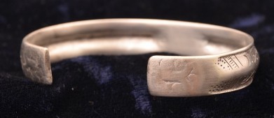 |
On each side of the central design are two more sets of leaves or petals yet only showing the outer edges of the leaves, as if the central flower is set in a chain of succeeding flowers which goes out of the observers view. The remainder of the bracelet, designated with the raised center line ridge—which appears to contain no inscribed designs— radiates outward from the center, first with a series of inscribed dots on each of the upper and lower halves. In our picture, there are 24 dots on the upper-right side, 20 on the lower-right side, 27 on the upper-left side and 27 on the lower-left side. This is followed on each side by three slanted, parallel lines with a set of notches running horizontally between the first and second parallel lines (or superimposed on the line). | |
| The same is true in the other direction, but only on one side of the centerline ridge. This is then followed by a pattern of swirled lines interspersed with singular dots with the exception of a set of 7 dots each on both sides of the centerline on the right side according to our picture and 8 dots each on both sides of the centerline on the left side in the orientation of the picture. This is then followed by another set of slanted parallel lines with horizontal notches between the second and third lines which give way to more incised dots, 8 dots on the upper right side, 8 dots on the lower right side; 15 on the upper left side and 13 on the lower left side. Further incisions are discerned on each outer side of the flattened terminal ends. They appear to differ in configuration from one another, however they are too worn to discern a clear design. These may resemble tamga marks (a tribal brand or impression), but is indeterminate. On this particular bracelet, a small patch of cloth (less than 5 mm2) was found on one of the terminal ends which was probably part of the female’s clothes or burial shroud. |
||
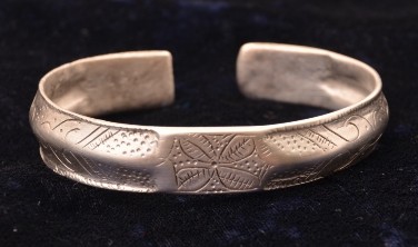
| Silver Bracelet (left arm, Ib_19_C_IV_089_I002_10.) | ||
This silver bracelet with an intricate design was found on the left arm of the female remains of L-089. It is one of a matching pair found on the right arm and also similar in design to a silver ring found on the fifth digit of the female’s right hand, in that the primary design in the flattened center of the bracelet contains a four-leaf rosette design. The bracelet was cast in a mold and the design etchings appear to have been done with a free hand with no uniform stenciling, yet with a similar pattern to its counterpart on the right arm. The loop of the bracelet raises slightly to a sloped peak and has a gap of 1.3 cm between each terminal end. The edges of the bracelet have a slightly raised ridge. Along the ridge of this bracelet, unlike its counterpart, there appear to be a series of slight percussion marks all along the raised perimeter ridges. |
 |
|
| The bracelet weighs 33.2 grams and measures 6.5 cm x 5.2 cm. The central design, the four- leaf rosette, appears in front of what appears to be a modified bolnisi or croix pattée-style cross which contains a series of inscribed dots (6 to 10 in number on each crossbar) with a larger dot in the center marking the flower’s pistil and or center of the cross, though this one is slightly off- center. The leaves, or petals, possess a pinnate venation on each leaf, but the artisan used different patterns, as with the lower leaves he simply struck a series of vertical lines intersecting the main vein of the leaf. The two upper leaves (based on the orientation of our photo) were incised differently, with the upper-left leaf containing 14 marks that do not intersect the center vein and the upper-right leaf with 13 marks, but each individual incision intersecting the center vein. Such differences by the artisan demonstrates that he/she was following a basic pattern with a free hand, but not a stencil and bound only by a general convention of design. That said, this bracelet follows an almost identical pattern that radiates out in each direction from the central rosette. Like the other bracelet, it appears there are two more sets of leaves or petals yet only showing the outer edges of the leaves, as if the central flower is set in a chain of succeeding flowers which goes out of the observer’s view. However, unlike the bracelet on the right arm, these petals possess less distinct marks and venation. The series of punctured dots follows. Based on our photo’s orientation, there are 22 dots on the upper-right side, 26 on the lower-right side, 22 on the upper-left side and 30 on the lower-left side. This is followed on each side by 2 slanted parallel lines (unlike the right arm bracelet which contains 3) with a set of 10 notches on the upper left side based on our orientation running horizontally along the line closest to the center and 8 notches on the lower left side running horizontally along the second line closest to the center. On the right side based on our orientation, it is just the opposite with the horizontal notches, a total of 6, appearing on the closer slanted line on the lower half and the notches, total of 9, appearing on the upper half on the second slanted line. As in the other bracelet, the design continues outward with a series of swirled lines interspersed with individual percussion dots with the exception of a set of dots on the upper andlower halves. On the left side of our orientation, the upper half contains 8 dots, the lower half 9. In the case of this bracelet, the right side is symmetrical with the left side in the same number of dots, 8 on the upper half and 9 on the lower half. |
||
 |
This bracelet also follows the same pattern as its counterpart with another series of parallel slanted lines, however, on the right side of this bracelet based on our orientation, there are only 2 parallel lines, instead of 3 as on the left side as well as on the other bracelet. There are horizontal notches on the second right-upper line and third right-lower line and on each of the second lines on the left side. As with the other bracelet, there appear to be incisions on each of the terminal ends which are difficult to discern, which may be tamga marks. There appears to be no difference in design from those on the right arm bracelet and are obviously meant to be the same type of mark. | |
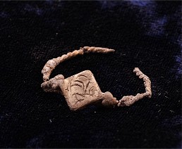
| Freshwater Pearl Earrings (Ib_19_C_IV_089_I009_17; Ib_19_C_IV_089_I008_16) | ||
| On each side of the head of the female in L-089, fresh-water pearl earrings with a bronze setting were found near the head. The right earring was more intact, containing the entire setting with 8 pearls of various sizes which were connected by a wire binding; however, the metal loop was fractured into three pieces. The right earring weighs 1.1 grams. |  |
|
| The left earring contained only the lower shaft and a total of 5 pearls of various sizes were found with this setting. Two of the pearls were still connected to the shaft. The pearls on both earrings range in size from 5.1 mm to 2.6 mm in diameter. Other earrings have been found in the graves of Area C, including those with freshwater pearls, which are indigenous to the area. | 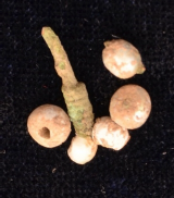 |
|
Significance of the Finds in L-089
The finds of L-089 provides a substantial amount of information pertaining to both this particular individual buried at the Ilibalyk Christian cemetery as well as cultural, economic, and religious connections of this city’s inhabitants. This report can only provide the most cursory of observations which later research by our team and other independent scholarly investigations can most certainly pursue in the future.First, the grave goods of L-089 do not appear to be characteristic of the majority of Christian burials from this location or time period. Children’s graves have a higher number of grave goods, predominately micro-sized glass paste beads in the form of a necklace, and in one case (L-026) a sliver ring with a raised bezel. Pantusov in the 1880s in southwest Semireche (today’s Kyrgyzstan) indicated that Christian graves contained only a limited number of grave goods (Kolchenko 2018) and while the records are not especially detailed, appear to confirm a very small amount of jewelry within the graves. One exception would be the grave found by Shashkina in 1986 of what she described as a “warrior-priest” due to the inclusion of weapons along with a gold leaf cross in the Durmen region of Uzbekistan (Shishkina 1994, 63). Therefore, when considering both our local sample as well as other graves in the region, one discerns that the grave goods of L-089 are quite exceptional both due to their rarity as well as their value.
Second, the grave goods of L-089 provide another example of definite trade links with this community. This was first demonstrated from the cemetery by the presence of a cowrie shell in L- 048 found in 2018 and again in conjunction with a grave this year in L-188. Such cowrie shells were utilized throughout Asia, in China during this period as well as India. Yang has clearly demonstrated their usage as currency (Yang, 2011). The shells themselves, based on their shape, are probably from somewhere in the Indian Ocean. While the grave of L-089 had no cowrie shells, the female was wearing two beaded bracelets with red coral. Red coral was considered quite valuable and traded throughout this region. While red coral may show links with the Mediterranean, it also is more likely to have come from the Indian Ocean area where two species of red coral are known (see Moradi, 2016). Medieval sources tell of how the coral trees were broken into smaller pieces for transport along the land trade routes. Not only was the coral considered valuable and possessed by people as far back at the Neolithic era, but also thought to possess protective and healing properties (Moradi, 2016). Trade connections may also be identified in the exquisite gold ring with green jade stone. However, further research would be necessary to determine if this ring is an import or domestic product. Both the jade stone and gold can be found in relatively local areas, the ornamental designs also point to a more indigenous influence.
Third, the elite nature of the woman found in the grave of L-089 cannot be denied. These items, which adorned her fingers, arms, and ears certainly communicate a person of high economic status. The fact that they were buried with the person in question in this particular context may indicate they were of great sentimental value, thus not kept by her decedents. It also infers that at least some of the Christians of Ilibalyk came from the upper class, or even the ruling class. This proves consistent with certain historical sources, particularly of Christian women from the Keriet and Naiman tribes, during the Mongol period, some of the most obvious being the wives of Genghis Khan and his sons (Weatherford, 2016, 102-116).
Fourth, this idea of elite ruling status for the female found in L-089 finds further support from the additional archaeological excavations that occurred at the site of the shahristan of Ilibalyk itself in 2018. This project, conducted by Baipakov and Kamaldinov, also under the auspices of the Society for the Exploration of Eurasia, found a horde in the niche of the fortress wall in this area, containing silver bracelets; necklaces with silver, carnelian, agate, turquoise and freshwater pearl beads; a jade pendant; a silver earring with freshwater pearls similar in shape and size to the earrings found in L-089; and also a necklace of red coral—which for the most part retained its beautiful color (Baipakov 2019, 33-41). Excavators date this horde and the excavations of the nearby monumental bath house of the shahristan area to the 13th century (Baipakov 2018, 13), which appears to be similar in time, if not a few decades earlier, with the burials at the cemetery in Area C. Both in material and design, the grave goods of L-089 demonstrate a link to the ruling elite of Ilibalyk due to similar economic status, artistic design of the jewelry, as well as with the precious materials used in their handiwork.
Yet, while the case is strong for a link with the local culture of Ilibalyk, the iconography found on the jewelry of the woman in L-089 also distinctly sets it apart religiously, which is probably the grave’s greatest significance. Given both the context—a proven Christian cemetery based on the gravestones’ inscriptions and the homogeneous burial customs identified via excavations— and the two specific designs themselves, the person in L-089 identifies herself as distinctly Christian. One gravestone discovered in 2016 specifically identified a female, Shirin the believer, as inscribed in Syriac. While this grave is not proven to be connected with the final resting place of Shirin, the inscription validates females professing the Christian faith, specifically the Church of the East, at Ilibalyk. Four pieces of jewelry possess a rather certain Christian identity in L-089: the silver ring with two inscribed four-leaf rosettes; the two silver bracelets, each with an inscribed four-leaf rosette centerpiece; and the silver alloy ring with the cruciform design floral pattern. Our analysis will show in the future that this image on the jewelry found in L-089 can be traced back as a symbol used in Christian art as early as the 3rd century AD.
Gravemarkers: Kayraks (Gravestones) and Fired Brick
In the 2019 season, excavators found an additional 9 gravestones, known in our context as kayraks. That makes a total of 34 stones discovered in what we have designated as Field IV at the Ilibalyk site. Eight of the nine stones found this year were in and around Area C. The other stone was discovered by a team member much further to the east than any previously found stone which raises more questions concerning the full extent of the graveyard’s boundaries. At least 4 of the stones can be classified as being in situ, with one most likely associated with a specific grave (L- 063) that was excavated. However, it must be remembered that the in situ classification must be tempered with the understanding that the area was an agricultural zone for most of the 20th century. This particular stone in association with L-063, when examined by Syriac experts in the field and via photographs agree that there might have been a partial, incomplete inscription at the base of the stone. All the stones are pictured and described below.A fired brick with a cross inscription was also found in Area C this season to add to the collection of bricks from last season which are now known to have been grave markers serving the same purpose as the stone kayraks in the cemetery.
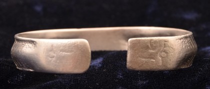
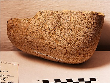
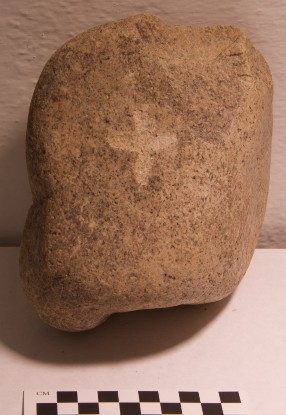
Kayrak 1 (L-062; Ib_19_C_IV_001_I002)
This gravestone was discovered during the initial clearing phase (Phase 1) of Area C for the 2019 season. It was in the western edge of the northeastern sector of what eventually was labeled L-106 and was eventually incorporated into U-7D. The stone was likely in association with the excavated tomb L-063. It is a whitish- gray, round granite stone with an incision in the “true cross” style with flared cross bars. It measures 19.5 X 19.5 X 6 cm. The chiseled cross incision measures 5.6 x 6 cm. It was discovered in situ at a level of 597.583 m asl.
This kayrak may contain a partial inscription in Syriac which was analyzed in the field by Dr. Erica C. D Hunter and Dr. Hidemi Takashashi on June 26, 2019. The inscription appears to read “in the year.” However, the inscription is quite small and in an unusual location, at the bottom of the rock. Thus, this may be merely a coincidental fissure in the rock. Another explanation may be that the rock was a practice stone for the stone carvers or a stone that was reused or an initial reject that was eventually placed, perhaps in haste.1 This hypothesis carriessome weight when taken in context with the grave in which it may be associated. The grave in L-063 is that of a juvenile probably less than 12 years of age (see L-063 description). The body in the grave is placed prone with the anterior of the body downward and the head apparently severed from the body with the crown of the head facing east, in the opposite direction of the rest of the body since the body’s placement in this way (upside down) would normally have the
![]()
1 This theory was suggested by Dr. Mark Dickens after looking at photographs of the stone. Email from Mark Dickens, September 15, 2019.
Kayrak 2 (L-197; Ib_19_C_IV_131_I001)
This stone was found during the course of excavations of a grave in U-7A (L-131/L-121). The stone actually lay in the far northern baulk of Area C, immediately north of the grave which had a unique wooden cover or possible coffin. However, because this northern section of Area C had been previously excavated during earlier seasons, the kayrak could not be designated as in direct association with the grave as it was possibly part of disturbed backfill. Its original designation was L-131 but was later reassigned as L- 197.The stone measures 16.5 X 13 X 4.6 cm and is a bluish-gray, smooth stone. The posterior side of the stone is rough and may have been cut by an agricultural plow. The shape of the stone is rounded on the side with the crude cross incision measuring 5 x 5.4 cm which was engraved on a slightly raised part of the stone. No further inscriptions were detected on the stone.
Kayrak 3 (L-128; Ib_19_C_IV_128_I004)
Kayrak 4 (no assigned locus; Ib_19_C_IV_000_I022)
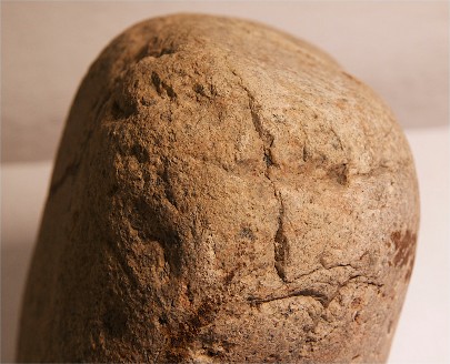
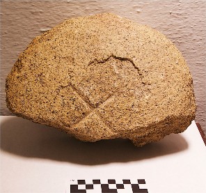
Kayrak 5 (L-130; Ib_19_C_IV_130_I001)
This gravestone was found in situ during the clearing of L-106 which was later incorporated into U- 8B. It was the largest stone found during the 2019 season and measured 32.5 X 18.5 X 8 cm. It is a grayish-white granite stone with a cross incision that measured 9 x 7 cm. The cross incision has flared crossbars on each end. Based on both the shape of the stone and the orientation of the cross not being symmetrical, this stone also might have been intended to be placed in a vertical position similar to photo on the right. At a slightly lower level, an anomaly in the soil which appeared to be a possible grave with mudbrick construction was originally thought to be in association with this stone (See locus description L-130). However, following excavations, no grave was found. Thus, the association of this stone with a particular grave could not be determined. It is possible that the associated grave lies to the east of the stone beyond the exposed soil east of Area C.
Kayrak 6 (L-215; Ib_19_C_IV_215_I001)
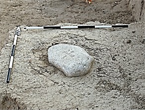
Excavators found this stone at the base of a tree in the center of Area C, specifically U-8B. The tree apparently grew on top of the stone which lay with its anterior side (the side with the cross incision) face down. The stone round stone is only slightly larger at one end and is a whitish-gray, granite stone which measures 22.5 X 20.5 X 5.5 cm. The cross incision is equilateral and measures 10.8 x 10.6 cm with flared ends. It is in the image of the “true cross” and contains a circular design in the center. This stone may be in association with Unit 4, L-009, an infant’s grave excavated during the 2018 season which lay less than 1 meter to the north of this stone. This stone was measured at a level of 597.936 m asl. The infant’s grave following excavation measured 597.764 m asl or 17 cm lower. However, given the density of the number of possible graves as well as the agricultural activity of the area, a final determination is in this instance is too problematic.
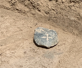
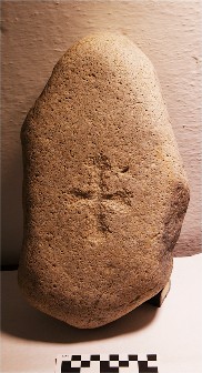
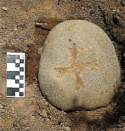
Kayrak 7 (No locus assigned; Area A surface find; Ib_19_A_IV_000_I001)
In the course of a surface survey in Field IV, a member of the excavation team discovered this kayrak (GPS coordinates 44T 410339 4886956) in an area that actually lay to the east and outside of our designated Area A. The stone, a pink granite, has been cut in half, possibly from a plow or other agricultural activity and measures 26.5 X 17 X 8.5 cm. The stone appears to have chisel marks around the edges to enhance its circular shape. In the center there is a clear, distinct “X” in what was probably the center of the stone, measuring 8 x 8 cm. The center area around the cross appears to have either flaked away naturally or flattened to create a smooth space for carving the image.
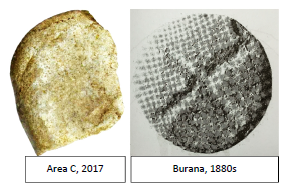
The simple X-shape with no other distinguishing features causes one to question if this is a kayrak with Christian iconography, or rather simply a tamga (tribal affiliation or identity mark). However, a small stone found in Area C in 2017 has a similar type marking (see on far left) which places it squarely within the Christian cemetery our team is excavating. In addition, a kayrak found in another cemetery in the 1880s at Burana (possibly the medieval city of Balasagun) in modern Kyrgyzstan also has a very similar iconography (Zhumagulov, 191). Thus, based on the contexts of the other two stones in comparison with this kayrak, our interpretation is that this is also a gravestone in conjunction with our other finds with Church of the East connections.
Kayrak 8 (L-168; Ib_19_C_IV_168_I001)
This rectangular shaped stone of whitish granite, almost in the form of a rectangular block, was found probably in situ during clearing operations in what was originally labeled L-106, the eastern expansion of Area C. It was eventually incorporated into Unit 8B and assigned as L-168. It measured 18 X 12 X 10 cm and the simply incised cross incision with no other ornamentation measured 3.6 x 3.2 cm. If the orientation of the stone is with the longer cross bar in the vertical position, then the lower-left section of the stone has a protruding bulge at the base. There is a rather large chip off the stone with three chisel or possible plow marks in the upper right side of the stone based on the orientation of the picture. The grave in possible association with this stone appeared to be a smaller-sized tomb (see L-168 description) but remained unexcavated due to time limitations. No further incisions or inscriptions were found on the stone. The findspot was recorded using GPS coordinates for possible further investigation of the grave in the future.
Fired Brick Grave Marker with Incision (L-001; Ib_19_C_IV_001_I012)
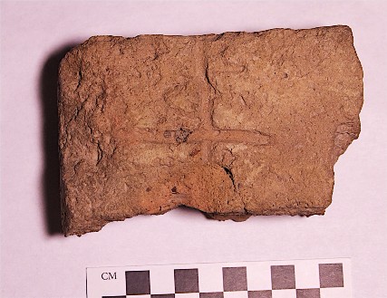
This fired brick fragment was found during the initial Phase 1 clearing operations within Area C in preparation for the 2019 season. It measured 12 X 7 X 4 cm and is partially broken. It has a crude cross incision probably made prior to firing of the brick with a finger. Based on the findings from 2018, this brick is probably a grave marker, which is similar to other fired bricks found in situ in conjunction with other graves and in the context of the graveyard.
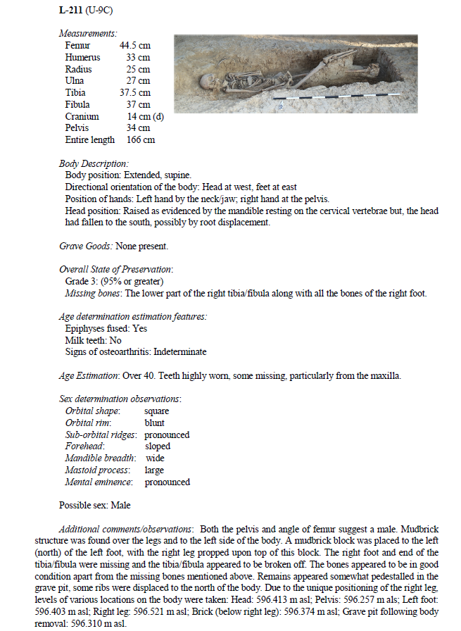
Metal Cross (No assigned locus; Ib_19_C_IV_001_I025_50.)
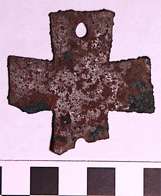
This cast metal cross—probably made of copper or a copper alloy—was found in the far southern baulk of Area C to just to the southwest of U-9C. It was found during preliminary preparations of Area C with the use of a metal detector at a level of 597.384 m asl. The cross measures 5 x 5 cm, thus of an equilateral design. It is 1 mm thick and weighs 10.3 grams. The cross’ arms each flare outward in the artistic style of a croix patee. One cross bar is slightly broken off at the end. The metal is highly corroded. There are two hole- piercings (one fully intact measuring 5 mm in diameter) in two opposing cross bars, implying that the cross was previously fastened onto an object or clothing. Metal crosses are rare, but consistent finds, in Church of the East contexts of Central Asia (Rott, 2005) and have were made of various materials including bronze, silver, and gold. They have also been found in contexts of graves (Shishkina, 1994). This cross certainly adds to the evidence that the cemetery of Area C is that of people identifying with Christianity as their primary religious expression. Further metallurgical analysis of this artifact is needed to determine its exact composition and mode of production.
Cowrie Shells (L-188; Ib_19_C_IV_188_I001/I002)
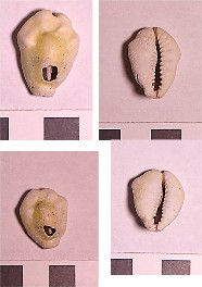
These 2 cowrie shells were found during clearing operations in U-8B in L-188, a possible grave with small dimensions (approx. 50 x 50 m) found in the east-central section of Area C at a level of 597.536 m asl. Since time prohibited excavation of this feature, it is not known with certainty if this actually was a grave. However, the discovery the shells provides support for that supposition. Both shells are similar in size (20 x 30 mm) and both have hole piercings in the posterior of the shell on the dorsal side. This was presumably for the purpose of wearing the shell either as a pendant around the neck or as part of a bracelet.
The shells have probably bleached white from the elements but do appear to have retained some of their natural color. While they need to be further analyzed by a specialist, it is probable that these shells came from the Indian Ocean. Regardless of their exact source of origin, such a find in Ilibalyk—one of the most distant locations from any ocean on earth— demonstrates trade connections of substantial distance. A cowrie shell was found in one grave (L-048) of a small child/infant to the northeast of L-188 during the 2018 season.
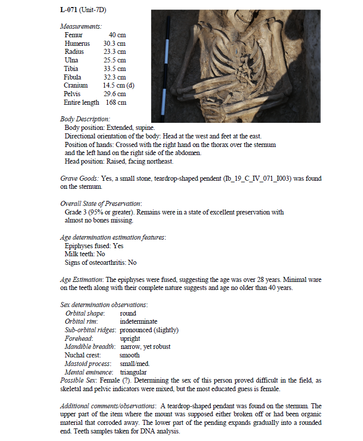
Stone Teardrop Pendent (L-071; Ib_19_C_IV_071_I003)
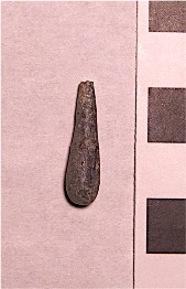
Glass Paste Bead (L-206; Ib_19_C_IV_128_I002)
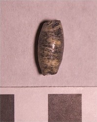
This glass paste black and white colored bead with a cylindrical shape was found in an adult male grave (L-206). It measures approximately 13 x 7 mm and has a through hole that runs horizontally through the bead. It was found at a level of 597.382 m asl in the thoracic region of the human remains. From this findspot it can be inferred that this bead was probably a pendant of a necklace worn around the neck. Based on the texture of this bead, it was probably manufactured via a method of winding molten glass.
Ucharal-Ilibalyk Burial Typology
All graves so far at Ucharal-Ilibalyk should be considered “pit burials”, which are inhumations where shafts were dug, bodies directly deposited within, and eventually covered with earth. There are also clearly several subtypes of grave constructions which, from our research so far, have not been identified within other medieval cemeteries in Central Asia. We have identified these four types.
Type 1.
Plain Pit – shaft cut in the earth; body deposited and covered with earth (no associated construction) (representing the graves uncovered in 2018, closest to the surface, such as Units 1, 2, and 6).
Type 2.
Brick-Covered Pit (with additional subtypes):
- Horizontal Mudbrick-Covered Pit – narrow shaft cut in the earth; a wider shaft is cut above this, forming ledges; body deposited; mud-bricks are placed horizontally on the ledges over body; finally this is covered with earth (as found in Units 7b, 7c, 7d ).
- Vertical Mudbrick-Covered Pit – narrow shaft cut in the earth; a wider shaft is cut above this, forming ledges; body deposited; mud-bricks are placed vertically (these may or may not have been perpendicular; i.e. they may have been slanted) on the ledges over body; finally this is covered with earth (as found in Units 3 and 5 ).
-
a. Gabled Mudbrick-Covered Pit – narrow shaft cut in the earth; a wider shaft is cut above this, forming ledges; body deposited; mud-bricks are placed at an angle forming a gabled roof on the ledges over body; finally this is covered with earth.
b. Gabled Fired-Brick-Covered Pit – narrow shaft cut in the earth; a wider shaft is cut above this, forming ledges; body deposited; fired-bricks are placed at an angle forming a gabled roof on the ledges over body; finally this is covered with earth.
Type 3.
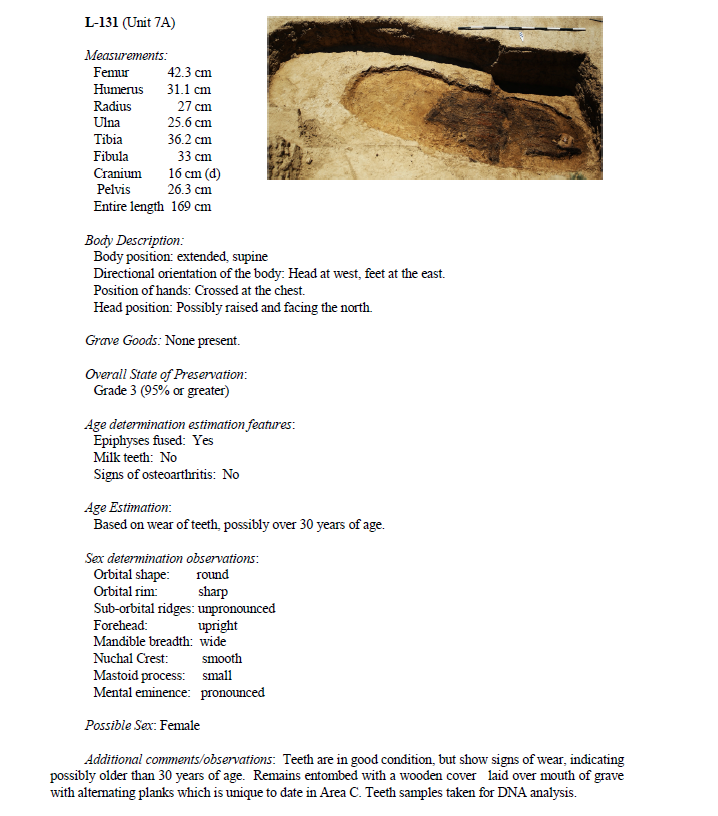
Wood-Lid Covered Pit - shaft cut in the earth; body deposited and covered with a plan of wood (as at Unit 7a).
Type 4.
Niche Burial – a large shaft is cut in the earth; in the side of the north section, a niche is cut; a body is deposited; a wall of vertically-placed mudbricks are placed sealing the body; the shaft is covered soil; and a mound of earth covers the entire grave (as at Unit 7d, L60 and L77).
Ucharal-Ilibalyk Burial Typology Construction Analysis
Excavating the graves at Ucharal-Ilibalyk has allowed our archaeological team to examine the complex burial process and analyze the different techniques that were employed. We provide the following diagrams that help illustrate the variety of each type. For the sake of uniformity, our illustrations show generic burials of an average adult male’s height (5.6 ft / 1.7 m) rather than a specific burial for each type, since all our burials have unique characteristics; therefore, it was more convenient to use a hypothetical adult burial to illustrate all the types, including those that, so far, were only used for infant burials.
At the moment it has been difficult to ascertain the depth of the burials from the original medieval surface of the ground. Because of natural deposit of soil, flooding, and yearly erosion, as well as heavy plowing during the Soviet era, the original medieval surface has not been identified, if it still exists. Because some of the burials have their mudbricks rather well preserved, we assume that each burial was covered with a mound of earth. This would explain why most of most of the mudbricks were intact and free from destruction by plant roots, even though their courses were often indistinguishable, susceptible to what we have called “melting”, that is the mudbricks were deformed and melded with each other. Another reason why we hypothesize that mounds of soil covered the graves is because that would explain how the medieval community was able to space out the graves in a somewhat regular pattern without accidently re-excavating unmarked graves.
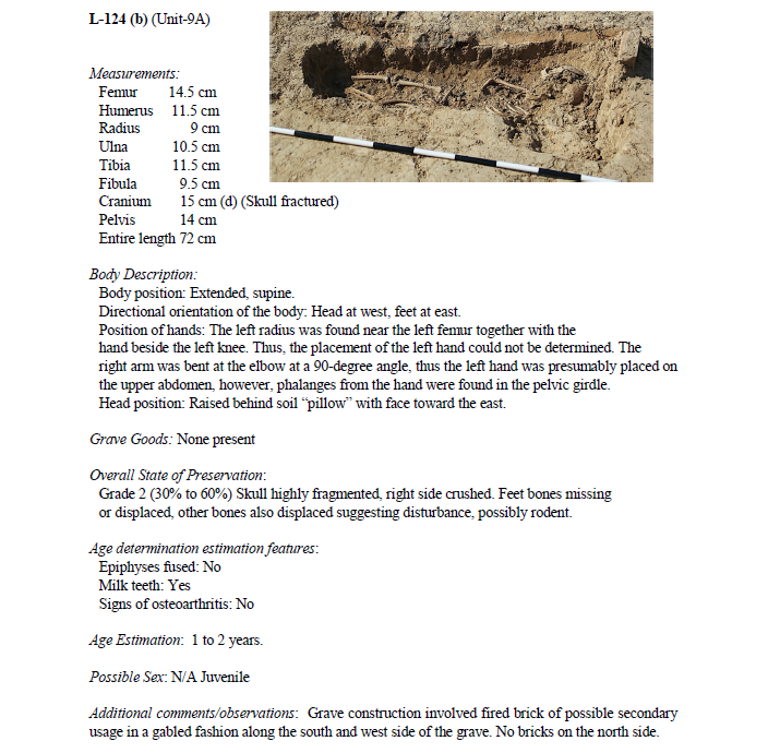
The sizes of the surviving mudbricks, which maintained their original form, varied considerably between each grave. For the below diagrams, we chose to base the mudbrick constructions according to the fired brick that covered one of the infant graves (Unit 9a, L124); these bricks measured 28 by 28 by 10 cm, which meant that the builders were applying units belonging to the Persian dva (hands), which was about 4 inches (10 cm). As such, these bricks were seven by seven by two dvas, which indicates a persistence of Iranic (Persian, Sogdian, Karakhanid, or Syriac) building culture in this area.
Type 1. Plain Pit
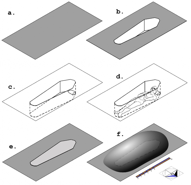
Diagram 1. Type 1. Plain Pit: a. plot is selected; b. a shaft is cut in the earth based on the size of the body of the deceased; c. a pillow of soil or a mudbrick is placed where the head is intended to rest; d. the body deposited; e. soil is placed over the body; f. a mound of earth covers the grave.
![]()
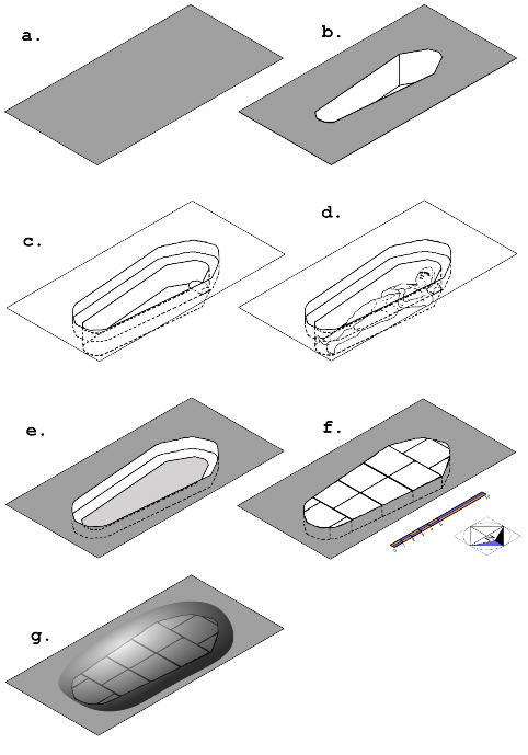
Diagram 2. Type 2A. Horizontal Mudbrick-Covered Pit: a. plot is selected; b. a shaft is cut in the earth based on the size of the body of the deceased; c. a wider shaft is cut above this, forming ledges, and a pillow of soil or a mudbrick is placed where the head is intended to rest; d. the body is deposited; e. soil is placed above the body to the level of the ledge; f. mud-bricks are placed horizontally on the ledges over body, and in some areas either the shaft or the mudbricks are cut to fit accordingly; g. the entire grave is covered with a mound of earth (as found in Units 7b, 7c, 7d ).
![]()
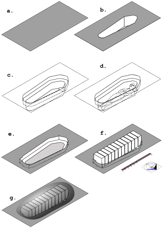
Diagram 3. Type 2B. Vertical Mudbrick-Covered Pit: a. plot is selected; b. a shaft is cut in the earth based on the size of the body of the deceased; c. a wider shaft is cut above this, forming ledges, and a pillow of soil or a mudbrick is placed where the head is intended to rest; d. the body is deposited; e. soil is placed above the body to the level of the ledge, and in some areas the shaft is altered so it can fit the mudbricks; f. mud-bricks are placed vertically on the ledges;
g. the entire grave is covered with a mound of earth (as found in Units 3 and 5 ).
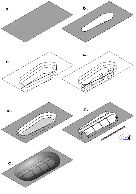
Diagram 4. Types 2C and 2D. Gabled Mudbrick or Fired-Brick Covered Pit: a. plot is selected; b. a shaft is cut in the earth based on the size of the body of the deceased; c. a wider shaft is cut above this, forming ledges, and a pillow of soil or a mudbrick is placed where the head is intended to rest; d. the body is deposited; e. soil is placed above the body to the level of the ledge, and in some areas the shaft is altered so it can fit the bricks; f. bricks are placed at an angle forming a gabled roof on the ledges; g. the entire grave is covered with a mound of earth (as found in Unit 9a ).
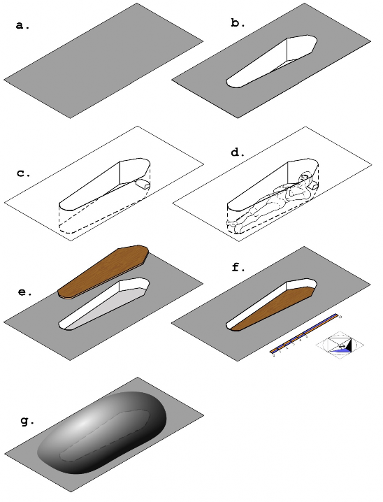
Diagram 5. Type 3. Wood-Lid Covered Pit: a. plot is selected; b. a shaft is cut in the earth based on the size of the body of the deceased; c. a pillow of soil or a mudbrick is placed where the head is intended to rest; d. the body is deposited; e. soil is placed over the body and a wood plank is cut to fit within the shaft; f. the wood plank is placed above the grave; g. a mound of earth covers the grave.
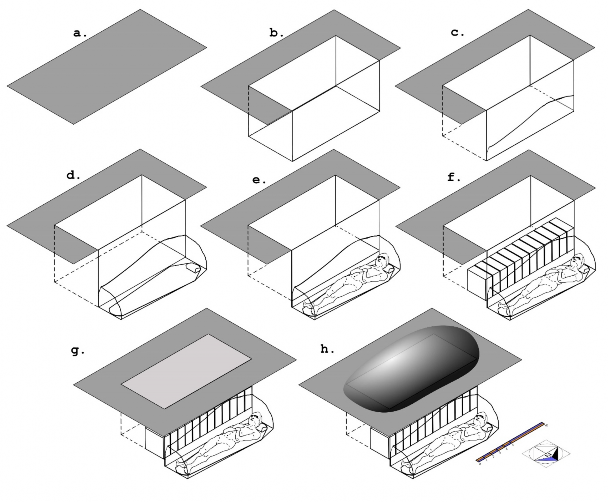
Diagram 6. Type 4. Niche Burial: a. plot is selected; b. large shaft is cut in the earth; c. in the side of the north section wall, a niche is outlined and prepared to be excavated; d. the niche is excavated and a pillow of earth or mudbrick is placed at the eastern end; e. the body is deposited; f. a wall of vertically positioned mudbricks is placed sealing the niche; g. the shaft is filled with soil; h. a mound of earth covers the entire grave.
2019 Radiocarbon Dating Analysis
Charles A. Stewart
Samples for radiocarbon dating were collected in 2019 during the Ucharal-Ilibalyk Excavations. The site today is within a government-protected forest, consisting of small trees and shrubs, just north of the modern village. By the fifteenth century this area had been abandoned. Later, during the Soviet era, the entire area was cultivated using tractors. Our initial excavations in 2016, indicated that this area was occupied during the twelfth and thirteenth century and, in 2018, our team was able to positively identify a medieval cemetery, 277 meters to the west of the Kara River. The exposed stratigraphy revealed only a few layers natural sedimentation, indicating that centuries of flooding, vegetation growth, and plowing may have removed the original medieval ground surface. Carbonized material was excavated from the graves and were sent to the University of Arizona’s Accelerator Mass Spectrometry (AMS) Laboratory for analysis. The AMS results were consistent with our relative chronology of the excavated artifacts and, moreover, the dating of the graves sheds new light on the interpretation of the medieval community.
Since the 2018 season, we have carefully examined and sifted soil during excavation, particularly in graves, identifying organic material which could be analyzed by means of radiocarbon analysis. In several burials, we recognized darker areas of soil that were assumed to be ash; unfortunately, most of these consisted of particles diffused thinly within the soil and too insubstantial to test. During the 2019 season, more solid carbon materials were identified within the soil-fill of the graves near the skeletal remains. These were then extracted using metal tools and placed in aluminum foil; then they were sealed in plastic zipper-storage bags, labeled, and packed. Altogether three carbon samples were specifically chosen for laboratory testing. The first sample was obtained by Elijah Hosse from Unit 9c, Locus 186, associated with an infant burial at an elevation of 597.132 m. The second sample was retrieved by Charles Stewart from Unit 7c, Locus 86, in a mudbrick-covered grave of an adult at an elevation of 597.109 m, weighing 120 mg; this consisted of small pieces of carbonized wood, located just above the rib cage on its left side. The third sample was excavated by Lauren Bryant in Unit 7b, Locus 85, in a mudbrick-covered grave of an adult at an elevation of 597.104 m, weighing 1640 mg; unfortunately, this sample contained humic material and dissolved during pretreatment.
The two viable samples came from graves that were about 32 meters from each other. The first sample (U9c, L186) had a carbon yield of 69.1% providing 1.61 mg for testing. The δ13C isotopic signature resulted in the ratio of carbon-13 to carbon-12 as -26 parts per thousand, providing a carbon-14 date 661 years before the year 1950, with an error of margin of 27 years. This indicates a medieval range between the years 1262 and 1313 CE; however, this may not be as accurate when compared to our knowledge of the fluctuation of radiocarbon in the atmosphere. When reassessed using the Oxford Calibration (OxCal v.4.3.2.) or International Calibration (IntCal13) methods, other date ranges were suggested: there is a 68% probability that the sample dates between 1285 to 1385 CE, or a 95% probability between 1278 to 1392 CE.2 The second sample (U7c, L86) had a carbon yield of 55% providing 1.23 mg for testing. The δ13C ratio measured was -26 ‰, indicating a carbon-14 date of 662 years before the present with a 19-year margin of error; thus dating between 1269 and 1307 CE. When recalibrated, there is a 68% probability that this wood was cut between 1286 to 1383 CE or, alternatively, a 95% probability between 1281 to 1389 CE.
![]()
2 R.E. Taylor and O. Bar-Yosef (2014) Radiocarbon Dating (London, Routledge, 2nd edition).
Overall Dating of the Ucharal-Ilibalyk Site
The carbon dating of the graves corresponds with our overall interpretation of the chronology of the site. Our working hypothesis is that this settlement was established as early as the 10th century and was almost completely abandoned by the beginning of the 15th century. In a preliminary numismatic study, 175 coins were examined that were found on the site; this consisted of collections from three different coin hoards.3 In summary, the earliest coin was Chinese dating from the Northern Song Dynasty (1023-1106) while the majority of coins (53%) belonged to the Chagatai Period, minted nearby at the capital of Almalyk (modern Khorgos, China), of which the latest one dated to 742 AH in the Islamic calendar, that is 1341 CE. The chronology reflected by these coins has been substantiated by the fineware ceramics throughout the site, the building phases of the shahristan, and the style of the epigraphy and iconography on the kayraks.
Excavations of the shahristan revealed the remains of a bath complex. During excavation of this building, five copper coins were found allowing relative dating of the stratigraphy. In brief, the upper most layers corresponded to activity during the 13th and 14th centuries; as we excavated downwards, we reached the second and third layers, indicating a residential area of the 11th to 12th centuries.4 We theorize that the earliest part of the Ilibalyk is centered in this shahristan area and as the population grew, rabads formed around the nucleus of the citadel area expanding outwards.
The dating of two other residential areas have also been established. First, in the northern rabad, our 2016 Excavation season exposed a residential complex, which we called “Area-1”. In relation with the bath, Area-1 was located 809 meters to the northwest, and about 200 m due east of the Kara River. A large amount of charcoal was taken from a hearth or oven.5 Its carbon-14 analysis indicated calendar range between 1130 and 1190 CE; however, when recalibrated, there is a 98% probability that the charcoal dates between 1207 to 1279 CE. Note that this house is located across the river from the cemetery, approximately 610 meters to the southeast. Near the cemetery, remains of another residential area, called “Area B”, was uncovered during the 2017 Excavation season; here several kayraks were uncovered. In Locus 2, an early 14th-century coin was uncovered with much ceramics and animal bone, providing evidence that this area approximately 100 meters to the east of the cemetery was either occupied by domestic housing or served as place of waste disposal. Clearly there was a relationship between “Area B” and the cemetery, which is still being processed.
With the carbon dates of the two graves, we can begin to analyze the cemetery as a contemporary phenomenon with these other areas of the medieval city. By examining the cemetery’s location, and its relationship with the rabads and shahristan, we will eventually ascertain the relationship of the Christian community within the social hierarchy of Ilibalyk.
![]()
3 P. Petrov, K. Baipakov, D. Voyakin, and D. Eresenov (2014) “The Medieval Town Found in the Valley of the Ili River (Numismatic Aspect),” Нумизматика Золотой Орды/Golden Horde Numismatics (Kazan) 4: 61-76.
4 D. Voyakin, T. Davis, D. Sorokin, I. Kamaldinov, S. Gilbert, S. Ortiz, M. Gurulyev, and C. Stewart (2016) Scientific Field Report on Complex Archaeological Investigations of the Usharal (Ilibalyk) Site (Almaty, Archaeological Expertise LLP, Kazakhstan), 270.
5 Ibid., 244.
Because our excavations are ongoing, we cannot provide a conclusive interpretation at the moment. We have three working hypotheses:
- The cemetery was established in the middle of the west rabad, where people lived in houses and worked.
- By the time the cemetery was established, the residential character of the rabad had been abandoned and it served as a waste dump; apparently, Christians were forced to bury their dead in what can be described as medieval landfill.
- Christians lived in the north rabad area and, across the river, established their cemetery in a place that had once been occupied by houses but were no longer used as such; perhaps this area had experienced decline before the other parts of the city.
The first hypothesis is problematic since it would be unusual for Christians in the Syriac tradition to be living so near a cemetery —it goes against the concepts of “ritual cleanliness” that the Syriac church held, rooted in biblical texts and traditions. In medieval Christian communities in north Africa, Asia, and Europe there is a long tradition of having churchyards dedicated to demarcating areas reserved for the dead, as the official liturgy mandated.6 The second hypothesis is also somewhat problematic, since there would have been ample land surrounding Ilibalyk that would have been more appropriate to sanctify as holy ground, if indeed, this area was once considered a space reserved for rubbish. The third hypothesis also is difficult to accept, since our excavations in 2016 and 2017 indicated that the area was occupied throughout the 13th and early 14th centuries since vast amounts of ceramics and butchered animal bone had been excavated flanking the cemetery, on the east and west sides. As we expand the excavation, it is hoped that a clearer picture emerges regarding the local context of the graves.
The carbon dating strengthens relationship of the Ilibalyk cemetery with other graves excavated in what is modern Kyrgyzstan during the late 19th century.7 At that time, Daniel Chwolson studied over 568 kayraks discovered in the Chu River valley and these were inscribed with the names of hundreds of people and dates, ranging between the years 1185 and 1345; moreover he noticed that 106 people died between the years 1338 and 1339.8 Ten inscriptions— which belong to the same date because they have similar epigraphy and paleography— specifically mention “pestilence”, which he interpreted as the Bubonic Plague.9 Chwolson mentioned that most of the names inscribed were Turkic, but other ethnicities are mentioned like Chinese, Indian, and Uyghur; eight people recorded on the kayraks were from Almalyk. Clearly the mortuary customs of these Mongol and Turkic Christians were widespread along the Ili, Chu, and Syr-Daria River Valleys and, moreover, the population was cosmopolitan and mobile, part of a global community.10 While we cannot be certain that individuals buried at Ilibalyk’s cemetery were affected by plague, the radiocarbon dates allow that possibility.
![]()
6 E. Hunter and J. Coakley (2017) “A Syriac Service-book from Turfan” (Turnhout, Brepols).
7 V. Kolchenko (2018) “Medieval Christianity of Kyrgyzstan according to archaeological sources”, Religions of Central Asia and Azerbaijan: Christianity 4 [“Средневековое христианство Кыргызстана по данным археологических Источников”, Религии Центральной Азии И Азербайджана: Христианство] (Samarkand, IICAS and Unesco), 48-103.
8 Chwolson, D. (1890) Syrisch-nestorianische Grabinschriften aus Semirjetschie (St. Petersburg: Commissionnaires de l'Académie impériale des Sciences), 28, 81, 84; (1897) Syrisch-nestorianische Grabinschriften aus Semirjetschie, neue Folge (St. Petersburg: Commissionnaires de l'Académie impériale des Sciences), 31-40; for a more recent treatment, M. Dickens (2009) “Syriac Gravestones In The Tashkent History Museum,” Hidden Treasures and Intercultural Encounters, eds. D. Winkler and L. Tang (Münster, Lit Verlag), 24.
9 P. Slavin (2019) “Death by the Lake: Mortality Crisis in Early Fourteenth-Century Central Asia”, Journal of Interdisciplinary History 50.1:59-90.
Our radiocarbon dates do have limitations, including its limited sample size and the rather long date range. Despite this, our understanding of the development of this city is clearer. We can conclude that these two burials were constructed during the first phase of the Chagatai Khanate, that is, prior to Tughlugh Timur Khan’s conversion to Islam in 1354, which had major societal consequences.11 Islamification coincided with the rise of the Timurid Empire, which annexed the western Chagatai domains, beginning in the year 1370, causing cultural and financial problems for the eastern Chagatai Khanate, which is often referred to by scholars as “Moghulistan” denoting a new political and Islamic state.12 Likewise, the Ming Dynasty in China rose to power in 1368 which did not tolerate Christianity and criminalized its practices.13 Christians living in the Chagatai khanate were facing pressure from both the east and the west, as well as in the capital of their homeland—that is, the city of Almalyk.
Almalyk, which was later renamed Khorgas, is located today in Huoerguosi-shi, China, and immediately across the border, the village of Almaly in Kazakhstan preserves the earlier name. Medieval Almalyk was located 52 km (33 miles) due east of Ucharal-Ilibalyk, and that distance seems hardly coincidental. An average trotting horse could take about four hours to cover 30 miles (48 km) and two hours at a fast gallop; this would indicate that Ilibalyk could serve as an important station along the imperial Yam system. Likewise, an average person could walk that distance within one day; that is, 33 miles in 14 hours. We theorize that both a political and commercial symbiosis developed between the two cities, forming a so-called “twin city” dynamic. The highway that connected Almalyk and Ilibalyk was located at the north of the city; therefore, the Christian cemetery would have been one of the first areas that a traveler would see as they entered Ilibalyk. For that reason, a metropolitan may have alternated his residency between Almalyk and Ilibalyk.14 When Tughlugh Timur Khan died in 1363, a grand mausoleum was built in Almalyk marking the zenith of Chagatai architecture as well as the beginning of its decline.15 Eventually, by the late 14th century, the capital had moved from Almalyk to Kashgar, further diminishing the role of the Ili River valley in international trade—as well as Ilibalyk.
10 T. Halbertsma (2015) Early Christian Remains of Inner Mongolia (Leiden, Brill); Gai Shanlin (1992) 阴山汪古
/Yinshan Wanggu: Gli Onguti di Yinshan (Hohhot, People's Press of Inner Mongolia).
11 S. Quinn (2003) “The Timurid Historiographical Legacy,” Society and Culture in the Early Modern Middle East, ed. A. Newman (Leiden, Brill), 19-32.
12 H. Kim (2000) “The Early History of the Moghul Nomads: The Legacy of the Chaghatai Khanate,” The Mongol Empire & Its Legacy, eds. R. Amatai-Preiss and D. Morgan (Leiden, Brill), 290-318.
13 X. Wang (1998) Christianity & Imperial Culture (Leiden, Brill), 83-88.
14 A city known as “Al-Faliq” was listed in “Amr’s list of metropolitans”; however, As Eduard Sachau and, more recently, Mark Dickens have insightfully pointed out, the city of “Al-Falyk” does not exist and this is probably a misspelling of “Ilibalyk”; Sauchau (1919) “Zur Ausbreitung des Christentums in Asien,” Abhandlungen der Preussischen Akademie der Wissenschaften, Jahrgang 1:1-80 (22); Dickens, “Syriac Gravestones”, 24.
15 B. O'Kane (2004) “Chaghatai Architecture and the Tomb of Tughluq Temür at Almaliq”, Muqarnas 21: 277-287.
With each successive season at Usharal-Ilibalyk, our team obtains more information and understanding regarding this community, who identified with the Christianity and specifically the Church of the East, located in this city in northeast Zhetisu. The discoveries of a significant number of adult human remains along with the newfound density of graves in the cemetery allow us to surmise that we have found the largest Church of the East (Nestorian) cemetery ever discovered. The initial analysis of the data collected during the 2019 season has led us to preliminary conclusions concerning this community and Ilibalyk as a whole as well as its place along a significant branch of the Silk Road from the 12th through 14th centuries.
Size and Boundaries of the Cemetery
While the size and dimensions of the cemetery have yet to be fully determined, we can confidently surmise that in the part of Area C that has been excavated, we find a significant concentration of graves throughout Area C. While a complete determination of the exact number of graves cannot be uniformly applied without complete excavation (a goal neither prudent, nor necessary), if the limits of the cemetery are discerned, it can provide us with a satisfactory estimate. Currently, based both on test units that were dug during this season (Units 10 and 11) along with the findspots of gravestones from the current and previous seasons, we can assert dimensions of at least 70 E/W x 60 N/S m. If two outlying stones (one discovered in 2017 another this season), are still within the boundaries of the cemetery, then the area covered is five time larger in size to 160 E/W x 140 N/S. This estimate, of course, is complicated by the ever-present understanding that our excavation lies in an agricultural zone, and stones could have been moved. However, given that both gravestones and graves appear in the same proximity as proven via our excavations of the past two years; it is more appropriate for us to state that very little shifting of the stones that are still in place in relation to the graves has occurred over the centuries.
If our estimate for grave concentration is accurate, then the cemetery discovered at Ilibalyk is the largest among the Church of the East adherents found in Central Asia. All previous excavations (aside from some individual graves excavated in the 20th century) occurred during Pantusov’s excavations of the 1880s until just after the turn of the century. (see Kolchenko, 2018; Pantusov 1886, 1903). This is not to suggest that Ilibalyk possessed the largest number of Christians in Zhetisu, but merely hypothesize that larger populations and more cemeteries may exist along a vast part of the region. As we have previously suggested, Ilibalyk represents the filling in of another missing piece of the puzzle that bridges the gap between the Christian cemeteries of Suyab (Akbeshim), Navakat (Krasnaya Rechka), Balasagun (Burana) and Bishkek in Kyrgyzstan along with Almalyk in today’s northwest China. When taken in context with the possible presence of Church of the East Christians in Kailyk (Koilyk) 230 km to the north, as confirmed by the writings of William of Rubruck and some of the cultural material from recent excavations (see Baipakov 2007, 86) then evidence exists of Christians living in at least seven major cities of Zhetisu from the 12th to 14th century with the possibility of more.
The ratio of gravestones finds to the number of currently revealed graves at almost 3 stones for every 8 bodies. It is obvious to state that not every interment was accompanied by a grave marker. It could also suggest that some graves may have been dug in haste due to possible epidemic. However, the most likely explanation is that the kayraks were removed over time, particularly during the early part of the 20th century when the collective farm of Usharal. Such stone clearing both for more productive agricultural purposes as well as utilizing larger stones in the foundation of the nearby village houses is a practice carried up to the present day in the area. We received confirmation from two villagers that the large one-meter stone (known as the Petro.
Stone) reported to officials in 2014 which provided the impetus for the entire project was almost placed in the foundation of a house, but later re-deposited back in the vicinity when its religious iconography became apparent to the homeowner. Utilizing former gravestones as foundation stones in construction was common with Nestorian Ongut graves in inner Mongolia (see Halbertsma, 2015).
The majority of gravestones found to date are small in size, easily held in one hand. In addition, some fired bricks with simple cross etchings have been found in conjunction with infant graves. The fact that even some of the smallest of children had their own grave marker seems to favor the idea that grave markers were the rule rather than the exception. Therefore, the large ratio between gravestones with the number of graves based on the current evidence suggests that many stones have been removed over time for various reasons. This may also explain why so few of the stones (4 to date) have epigraphy, since the larger stones that we have found are those with writing on them. While other explanations, such as a lack of literacy of the overall community or the significant number of children or infants who may have never been given names could explain the lack of epigraphy, smaller stones escape the notice of farmers, or are more troublesome or unnecessary to extract. It should finally be noted that the period of Soviet agricultural collectivization likely de-emphasized the need to preserve stones with religious significance or identity or were ignored by the local populace seeking to establish their new community in the early 1930s.
This stands in contrast to the work of Pantusov during the 1880s in southern Zhetisu, who had Russian colonial backing and was himself a colonial official living in Almaty. At that time, there was an extreme interest on the part of both local authorities as well as the European scholarly community over the gravestones being uncovered in the Chui River Valley. Agriculture, being done by Russian farmers recently relocated in the region in soil gone fallow for hundreds of years due to the predominance of the nomadic lifestyle of the indigenous populations, revealed the gravestones in that area which were reported to and observed by colonial officials sympathetic to their symbolism and intrigued by their forgotten history. Yet, even at this early period, Pantusov complained about looting of graves and removal of gravestones which hampered his efforts of recordation and resulted in loss to the archaeological record. (Samigulin 2011, 160).
Three seasons’ worth of data from Area C is beginning to provide us with a gradually emerging picture concerning grave placement, arrangement, and depth in conjunction with gravestone finds. In addition, with 2017’s ground penetrating radar scans in relation to actual excavations will hopefully provide an understanding of what is observable from that data. We also have a possible child-to-adult ratio (5:3) as well as male-to-female ratio (3:4) amongst the adult skeletons. This information is, of course, qualified by our field forensic estimates and will need confirmation from a qualified forensic pathologist. Grave placement combined with grave construction analysis does appear to provide some slight differences in grave construction based on location. For example, graves found in Unit 7 are a high concentration of adult graves in rather uniform placement, utilizing horizontally placed mudbrick supplemented by a soil ledge around the grave perimeter. Unit 3 and Unit 5, which lay to the south and southeast of Unit 7, however, appear to utilize mudbrick placed vertically across the tomb with the head of the skeleton covered with a layer of soil and no brick.
Our comparison data also allows us to see where certain gravestone findspots lay in relation to the excavated graves. While we have thoroughly discussed the agricultural impact which makes knowing exact findspots problematic, it is significant to note that the Yoshmid Stone, which marks a dual grave with Barshabba Kucha, lies almost due west of Units 9C and 3. In fact, the rather curious grave of L-211 which is that of an adult male whose right leg was either intentionally elevated and placed across his left leg, or whose enigmatic placement was the result of a disturbed grave, lay due west of the Yoshmid Stone by approximately 2 meters. While there is no way to associate this gravestone with this particular grave, the area is worth noting for more analysis, as it may indicate higher status individuals. This is further enhanced with the knowledge that the bronze cross found in the current southern baulk of Area C is also approximately 1.5 meters from the Yoshmid Stone findspot.
Burial Practice Comparison
A second significant interpretation that can be drawn from excavations of the cemetery to date is that juveniles appear to have been interred with more uniform burial practices than those of adults. This season’s results provide us a much better comparison of adults with juvenile burials. Of the 81 graves we have excavated, 32 are adults, 49 are juveniles (which are defined as those remains whose epiphyses are unfused, with partially fused epiphyses grouped with adults). As explained in the 2018 report, head and hand placement overwhelmingly were the same, with the hands crossed at the waist/pelvis and the head raised with the chin often resting on the sternum facing east. Children also have a higher concentration of grave goods (22% of all juvenile burials), predominately very small glass paste beads, usually in the form of a necklace, whereas only 3 of the adult graves contained jewelry accompanying the body, with L-089 as the most extraordinary example.
Adult head placement varied greatly with most raised, but with the faces placed at various directions. In some cases, determining the exact direction of the face was complicated by possible shifting of the soil or from vegetative root disruption. Other bodies were more difficult to discern because the placement of mudbrick may have disturbed the skull from its original placement. Hand position also varied significantly with hands often across the torso in various arrangements. In a few cases, the hands were straight along the sides, or were both placed over the sternum/heart area.
The question of grave clothes and/or a shroud remains unanswered, however, the micro- sized piece of cloth found on the right-arm silver bracelet of the female in L-089 probably provides proof of some sort of shroud, or, at the very least that the deceased was buried with clothing. Another interesting grave was that of L-121/131 which was buried with a wooden covering. Church of the East Christian graves in southern Zhetisu and the Taraz region have been found with wooden coffins, but the number of such burials is not clear. Another outlying grave, that of L-063, in which this juvenile body was placed anteriorly yet with the head detached with the top of the cranium facing east with the face downward left excavators baffled as to an explanation. This could indicate anything from trauma, hasty burial, mishandling of the body, or some sort of ceremonial symbolism at the time of interment. Nothing is comparable either with the other graves in Area C or anywhere else in the current archaeological context.
The 2018 report indicated the presence of several ash pits with animal bones and charred cookware pottery. The interpretation drawn was that of possible funerary meals which occurred at the time of burial. While this cultural evidence is still there, this season’s excavation revealed that some possible locations thought to have been ash pits seen in the soil may actually have been mudbrick with ash fill. This is not true in all cases, however, particularly from Units 3 and 5 in which ash pits along with charcoal, animal bones and cookware potsherds were quite evident. In addition, two graves may have had an accompanying ash pit with animal bone and cooking pottery (L-100, L-080) in U-7D. While not uniformly consistent in connection with all the graves, evidence still exists for funerary meals in conjunction with some burials at least.
The previous year’s report also indicated that singular pieces of pottery, particularly of a glazed type appeared to have been intentionally included in the grave. An alternative explanation to intentional placement is the idea that the potsherds found in the grave were temper included with the soil of the mudbricks used in grave construction.
On a final note, small river stones—sometimes as many as 3 or 4— continued to be found in the grave, often placed at the elbow or within the hand itself. Again, this practice appears more common in juvenile graves than adult graves. The reason behind this practice remains unknown.
Thus, our understanding of burial practices now that a more significant number of graves, particularly adult graves, demonstrates varied practice among adults related to body positioning and grave goods. However, the most consistent practice, that placing the body with the head at the west and the feet at the east remains consistent. While the coordinates sometimes vary slightly (possibly due to the seasonal adjustment of the earth’s axis in relation to the sun?), it seems obvious based on this feature that the community buried in this cemetery come from the same religio- cultural tradition. This is based on the uniformity of the gravestones found in both the iconography (the cross) and the 4 gravestones with written inscriptions as well as the metal cross found in the same vicinity. These factors put together clearly demonstrates a connection with the faith and practice of the Church of the East. To date, no other burial practices or cultural material points to any other cultural or religious tradition in this particular location.
A concluding word should also be included concerning grave construction. This has been discussed in the Burial Typology section with the general comparisons provided. The construction of the graves as examined in Area C most closely resemble the grave construction as found in other Church of the East contexts, specifically those as recorded from the 19th century excavations in today’s Kyrgyzstan and the individual grave excavations in southern Kazakhstan as reported by Baipakov. (Baipakov 2018, 14.) While such records are far from complete and archaeological methodology not as advanced nor possessing the advantage of digital photography to confirm the data with the drawings that do exist, directional orientation; the use of mud and fired brick; and the various methods of construction do appear similar.
Probable Indigenous Ethnicity
Discussions concerning ethnicity and ancestral origin are fraught with difficulties. This archaeological report will not seek to address that issue, however, one of the most basic of questions when considering the humans interred in this particular cemetery and as it relates to adherents of the Church of the East is, “Who were these people?” Anecdotally, when the general public of Kazakhstan and Central Asia has learned of our excavations, various popular hypotheses range from “a band of traveling Europeans” to a rather strong certainty that these are the remains of the Turkic-Mongol Naiman and/or Kereit. Currently, only very preliminary DNA analysis has begun which still need more in depth analysis. We can say that both these early results as well as the physical evidence itself, points to a wide variation of ethnic identity.
While more thorough analysis may be forthcoming, there are certain clues that the archaeological record has provided, including forensic analysis from this season. The most obvious indicator of ethnicity (while certainly not free from error or alternative explanations) is the linguistic evidence from the 4 gravestones with written inscriptions found in 2016 and 2017. Three of the four stones are in Old Turkic, sometimes known as East Old Turkic or Old Uyghur, but utilizing a form of eastern Syriac script. It could also be further delineated as being a form of Turkic with Syriac influence due to the obvious connections with the Church of the East whose ecclesiastical language was Syriac, specifically East Syriac. One stone in the Ilibalyk corpus (the Shirin Stone) is in Syriac. While the sample is quite small, 3 of the 4 stones are likely in the language of the local, indigenous population from the time period, 12th – 14th century. It is logical to assume that Old Turkic was the local language spoken by the inhabitants of the city and region, thus the adherents to the Church of the East recorded their honored dead with epitaphs in a language they spoke on a daily basis.
A second example of cultural connection with the indigenous population would be the comparison of the jewelry found on the female remains of L-089 with a jewelry horde found in the walls of Ilibalyk’s shahristan in 2018. While not identical in type and design, the bracelets, necklaces and earrings from the horde found in a niche of the wall dating from the 12th century show similarities in both design and materials utilized such as carnelian stones, silver, and ocean coral, all materials utilized in the grave goods found in L-089. In addition, while the artistic designs on the jewelry of L-089 had distinctly Christian symbolism as noted in our report; they also contained some common patterns and designs often characteristic of Central Asia, and even modern Kazakh art.
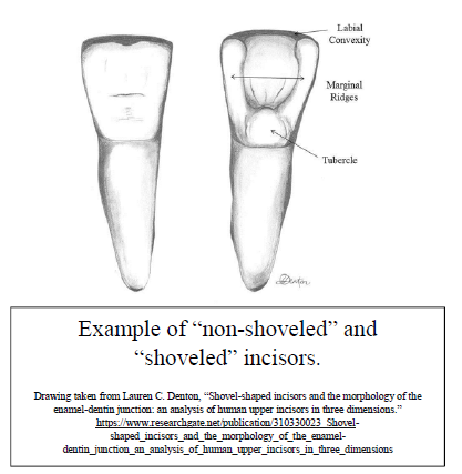
The most basic of field forensics conducted by our team during the Area C excavations this season of the adult graves also provides a possible confirmation of the indigeneity of those interred in the cemetery. Skeletal remains, unlike soft and molecular tissue, provide very little clue as to ethnicity and there are no exact skeletal markers that correspond exactly to geographic origin. Osteologists, however, do consider one dental characteristic as one of the only possible indicators: shoveled incisors. Incisors, or the front four teeth on both the upper and lower jaws, are often characterized in people of Asian descent by scooped lingual surfaces. While expert osteologists in recent years have clearly shown that dentition varies widely around the world and such variation can call into question the reality of confident identification of an Asian population, a high incidence of shoveled incisors are found in Asians. (White, 402).
While the field forensic analysis of our team can only be considered cursory, several instances of shoveled incisors were noted. Certainly, shoveled incisors are far from definitive proof that the human remains in Area C are indigenous; however, taken together with the linguistic and cultural material evidence, the case is building that those interred outside the walls of Ilibalyk were residents of the city itself and from the local population. We anticipate that further information will soon be available.
Connections with Global Medieval Christendom
Due to the fact of the Church of the East’s connections to the misnomer of Nestorianism (this branch of Christianity and its history fell into neglect, particularly once adherents to this religious confession disappeared from China and Central Asia by the 15th century (Jenkins, 2008). While the divisions between Roman Catholic, Eastern Orthodox, Coptic, and other Eastern Rite churches should not be minimized, it is also an exaggeration that the Church of the East was completely ignored of unknown during the medieval period, even in the West. Scholars through the centuries have noted the presence of Christians along the Silk Road as testified by the rumors of the realm of Prester John (a supposed Christian king and kingdom beyond the land of the Muslims); the journal of William of Rubruck’s travel during the united Mongol period; and the fanciful recordation of Marco Polo. That these connections were a two-way street is demonstrated by the story of the two Ongut monks, Rabban Sawma and Rabban Mark who recorded their impressions on a visit all the way to medieval France (See Budge 1928).
The cultural material discovered at Usharal-Ilibalyk appears to affirm the continued connections with medieval global Christendom. This is borne out in two ways: First, the cross iconography of the gravestones themselves, and second, via the designs on the jewelry found on the female in Locus-089. Dr. Charles Stewart, the art historian and archaeologist who is a prominent member of our team, provided a survey of the cross iconography as found on the gravestones in the 2017 field report. In that survey he provides evidence that there is really no such thing as a “Nestorian cross” but rather various designs as found on the gravestones of Ilibalyk (as well as the entire Zhetisu corpus) have counterparts in the West (See 2017 field report) during the same time period.
The “true cross” image—which is characterized as the cross with flared ends, resembling plant buds or flowers, with the circular design in the center at the intersection of the cross beams— appears to be a very common motif found among the stones of Ilibalyk (a total of 8, or almost 25% of the gravestones utilize this iconography). While this report cannot provide a full account of this particular motif, suffice it to say that such iconography has connections to the True Cross reliquary as found at the Church of the Holy Sepulture in Jerusalem as well as possible connections with the Persian Empire of the 7th century, in which Shirin, the Christian queen of Persia with known connections to the Church of the East, built a church in Persia to house that exact reliquary box (Baum 2004, 46-53). Knowledge of this historiography is not lost on the fact that one of the four gravestones with inscriptions from Ilibalyk contains a possible namesake for this queen.
The connections with the greater Christian world can also be seen, as mentioned above, in the design motifs of the jewelry from L-089. This is particularly true of the four-leaf rosette found on the bracelet and ring combination. Future analysis and publications will demonstrate that the rosette with the Bolnisi cross behind that of either leaves or flower petals of an almond bud, appears to have been a symbol used in various Christian contexts stretching from Portugal to China spanning a millennium of usage with the earliest known example from a church mosaic in Megiddo, Israel in 230 A.D. Interestingly, the same design has been found on silver or gold bracelets or rings contemporary with the findings in L-089 from both within Kazakhstan (Kailyk and Kumishi) and parts of inner Mongolia from a region where Ongut Turks lived, who also had Church of the East adherents. Again, this research and analysis is forthcoming.
While, certainly, these design motifs can be found outside of Christian contexts and the design found in isolation cannot provide proof that either individuals or populations identified themselves as Christians; the motif as identified in L-089 in the context of a Christian graveyard cannot be dismissed as insignificant or coincidental. Thus, the four-leaf rosette in this context demonstrates a possible regional and global connection to medieval Christendom and a possible symbol used by Christians of Zhetisu/Semireche during the late medieval period.
Trade Links along the Silk Road
Not only does the material culture found in the cemetery provide evidence of religious connections, but also trade. Once again, the jewelry of L-089 provides us with a clear connection. The two bracelets with beads of semi-precious stones, glass paste beads, and, specifically, the ocean coral demonstrate commercial connections of several thousand kilometers. Red coral can have several potential sources, most famously the Mediterranean, however, the Indian Ocean contains two possible species used in jewelry production. According to Moradi, trade in coral occurred between the Indian Ocean linking Tibet and Mongolia (Moradi, 130-131). Apart from laboratory analysis to provide us with information concerning the exact species of coral; this link to the Indian Ocean given the proximity and known history of Ilibalyk and its political links with the Mongolian empire; is our best guess as to its source.
As we previously mentioned, a red coral necklace was also found in a horde discovered in the wall of Ilibalyk’s shahristan in 2018. Use of coral in jewelry in worldwide contexts dates as far back as the Neolithic and even Paleolithic eras (Moradi, 128). The ancients considered it to have curative and spiritual powers. Thus, this material was probably a valued import not merely as decorative or a rarity, but for spiritual and religious connotations. While many Christian confessions and theologies would frown on a syncretistic expression of the faith, the bead bracelets found on the female in L-089 may indicate a mixture of religious faith and practice. Such a syncretistic religious practice on the part the Turkic peoples of Central Asia, and specifically those with Nestorian Christians of the 13th century as certain original sources confirm, specifically William of Rubruck, while debated, must be considered.
Further trade connections with the Indian Ocean are also found in the three cowrie shells found across the past two seasons. One shell was found on an infant’s body, probably as the pendant for a necklace in Locus-048. Two shells were found while clearing around a possible infant’s grave this season in L-088 In Unit 8B. All three appear to possibly be from a species from the Indian Ocean, however, final analysis is still pending. Cowrie shells are known not only as jewelry, but also as currency, even in China during medieval times (Yang 2011). Thus, while cultural material in the graves of Area C is scant in comparison to other contexts— particularly bronze and iron age sites of the region— what has been found provides us with confirmation that the northern trade route which connected Ilibalyk with the rest of the world provided its inhabitants with trade goods from distant locations. In addition, such trade was engaged in by at least some of the Christians of the city, demonstrating that some of their population possessed significant economic means to engage in such trade.
The past four seasons of investigative excavations at Usharal-Ilibalyk have provided a significant amount of information regarding both this medieval city along the northern trade route of the Silk Road during the later Medieval Period and specifically during the Karakhanid and Mongolian empires which ruled this region. It has provided even more information regarding the community of adherents of the Church of the East (Nestorian) as a result of the investigations of the cemetery located on the northeast side of this large medieval city. This preliminary report, in conjunction with the previous seasons’ reports, represents archaeological investigations that have provided the most significant advance in Nestorian studies of more than a century. Thanks to the fresh examination of the previous data (see Kolchenko, 2018), we are also able to begin to draw comparisons and contrasts with other Church of the East sites in modern Kyrgyzstan, particularly related to burial practices. It is also promising to learn that further archaeological investigations at sites, such as Ak Beshim in Kyrgyzstan and Urgut in Uzbekistan are also on the horizon.
For all the information that the past four years’ worth of examination have provided, many questions remain. Most basic is the exact size of the cemetery itself. As mentioned, we have only been able to examine less than 50% of Area C and this has revealed a possible 145 total graves (though 67 possible graves have not be excavated to date). In 2017, Areas, A, B, and C were first delineated with preliminary units revealing more gravestones in Areas B and C. Area A, which lay further south than the other areas, yielded no additional stones. In 2018, a section between Areas B and C, which was covered by heavy thorn bushes, was also delineated and a surface survey was conducted, revealing both surface pottery and one possible kayrak (gravestone), this was designated as Area D (81 E/W x 65 N/S m). This season, another kayrak was found much further east of all the previous finds, which could indicate an even more extensive area than previously surmised.
As an attempt to gauge the cemetery boundaries to the north and south in Area C, test trenches (Units 10 and 11) were excavated. As expected, L-010, which lay within the original boundaries of Area C continued to reveal cultural material, including human remains for an additional 20 m south. Unit 11, however, yielded less cultural material and only one possible grave rather close to U-7A by only 5 m. This suggests that we may have reached the northern boundary of Area C specifically.
Eastern and western boundaries of the cemetery are even less certain; however, the 2016 excavations lie approximately 100 meters east/southeast of Area C which revealed a small structure with courtyard and a trash pit to the south of that structure. Neither evidence of graves nor gravestones was found. If the northern boundary of Area C is relatively uniform in a west-to- east direction, which is not a certainty, then we can currently very roughly estimate the largest possible extent of the cemetery area as 160 E/W x 140 m N/S. A more conservative estimate based on more than just gravestone findspots would make it 60 (N/S) x 70 (E/W) m. In concert with previous Ground Penetrating Radar scans of Area C where we have definitely discovered graves, it may now prove possible to utilize GPR more effectively in finally discerning grave constructions. However, further analysis and more test trenches are necessary. Simply put, we still do not know the exact dimensions of this cemetery.
Another major question concerns possible ecclesiastical architecture, either in the form of a church building itself, or perhaps a funerary chapel used for the dual purpose of burial preparation and rites. Small structures were found in both 2016 (the small building with courtyard to the southeast of Area C) and 2017, an outdoor kiln and possible domicile, located in Area B which at that time were interpreted as a later phase of construction that occurred after the cemetery was no longer in use and possibly forgotten. However, a reexamination of the data and further excavations may be in order for two reasons:, First, some of the pottery and numismatic evidence (one coin was found) may indicate contemporary occupation with the cemetery. Second, the excavations of Area B occurred prior to the location of any graves and a recent examination of photos of Unit 4 where this possible domicile was located show a possible grave located near or even underneath the structure.
The possibility of a funerary chapel near or even inside the cemetery is reasonable to assume. A Syriac service book from Turpan, China, found during the German expeditions in the first decade of the 20th century and recently translated by Hunter and Coakley reveal sequences, or stations, during a funeral for both clergy and laity. A funerary chapel is listed as one site location for liturgical prayers. (Hunter 2017, 237.) While this may be scant evidence for the layout and funerary practices as conducted in Ilibalyk, it should not be ruled out. Given the significant number of graves found; inscriptions that reveal the presence of clergy on two of the gravestones; and the affirmations concerning the congruity that all of the graves come from a homogeneous religio-cultural community, the possibility of a funerary chapel or even a church building itself seems strong. The large size and limited excavations make finding a church quite difficult, however, finding a funerary chapel located near or even inside the graveyard is within reason. That said, now that we have determined that a significant number of Church of the East Christians lived at Ilibalyk, it could also be reasonably assumed that somewhere either within or outside its walls, the city housed a church building. Thus, where might these structures be? A more thorough topographical examination of the area both around the cemetery and around the site as a whole is in order, though certainly a daunting task.
Finally, based on the cultural material of L-089, what is the full extent of the use of the four-leaf rosette design as found in at least four locations in Central Asia and northwest China? The scope of this design’s diffusion— which could have been adopted and utilized by many others besides just Christians in the region— may serve as historical “bread crumbs” in finding potential new locations where communities of Central Asian Christians lived. The current locations, particularly Kymischi and Kailyk within Kazakhstan, deserve a more thorough examination, not merely due to the presence of the rosette, but also due to the historical and geographical context in which the design was found. A re-examination of the existing cultural material as well as these sites could expand our knowledge of the scope and reach of the Church of the East in Central Asia, and specifically modern Kazakhstan, contemporary to Ilibalyk.
Collective Inventory of Selected Discovered Materials
[FOR A COMPLETE INVENTORY SEE UNABBRIDED REPORT]
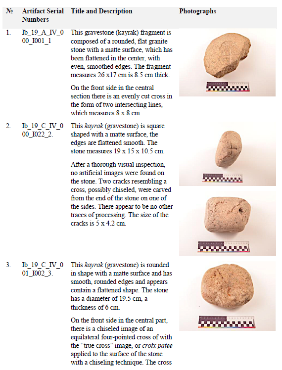
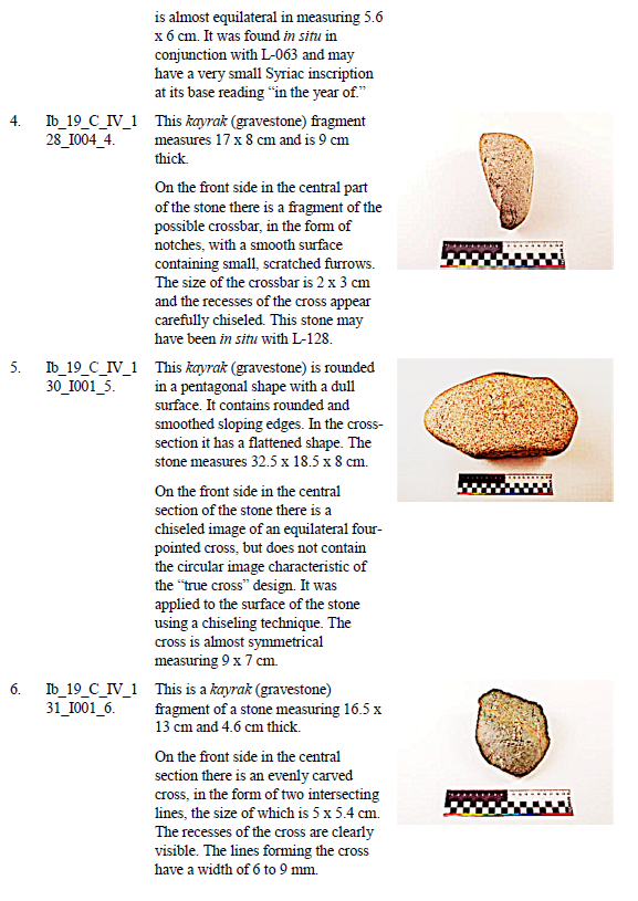
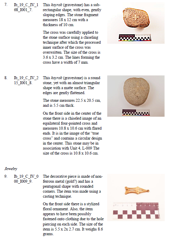
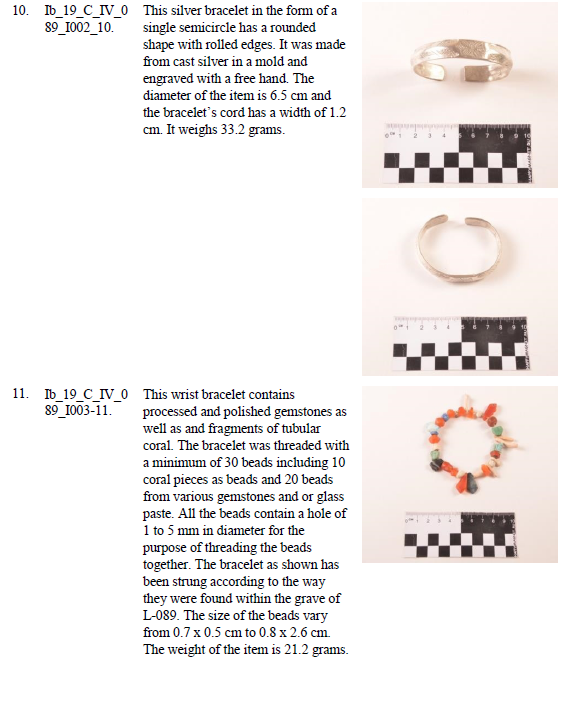
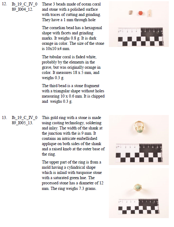
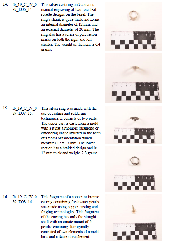
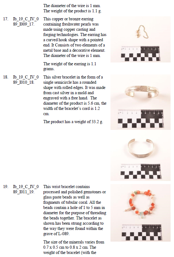
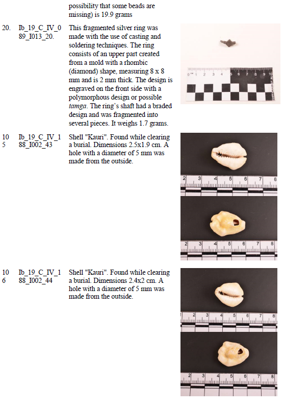
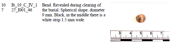
Drawings of finds
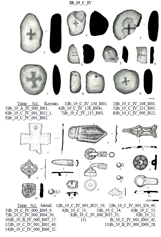
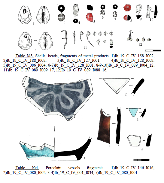
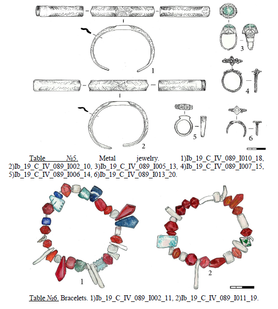
NUMISMATICS
For written descriptions on numismatic finds, consult unabridged report upon request of the Society for the Exploration of Eurasia.
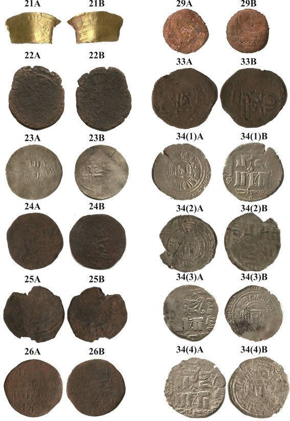
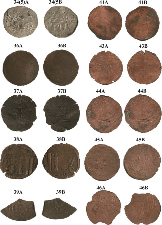
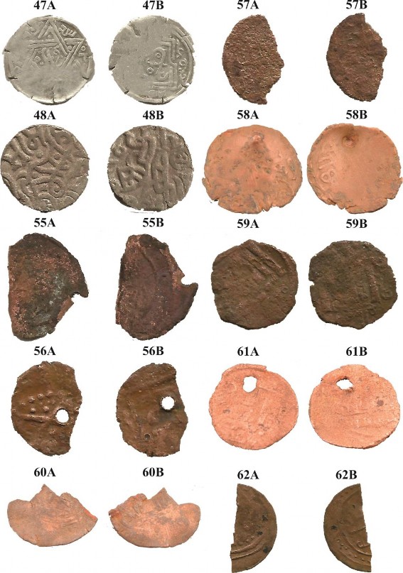
Description of Ceramic Material
For descriptions of ceramic material, see the unabridged report available upon request from the Society for the Exploration of Eurasia.
Photomaterial
The complete photo catalogue is available upon request from the Society for the Exploration of Eurasia.
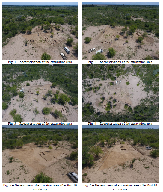
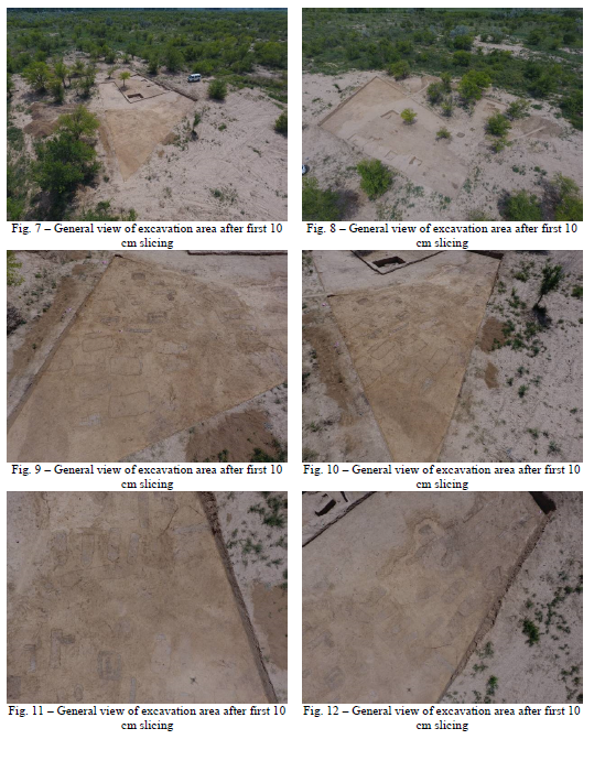
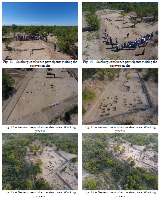
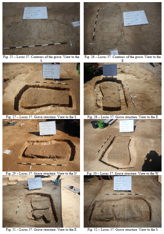
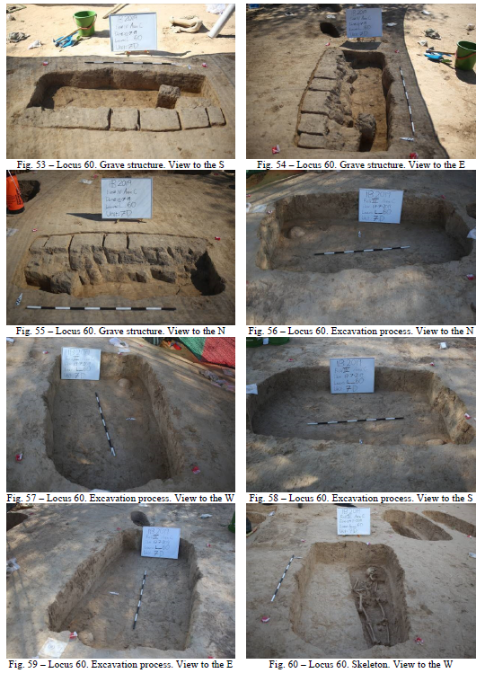
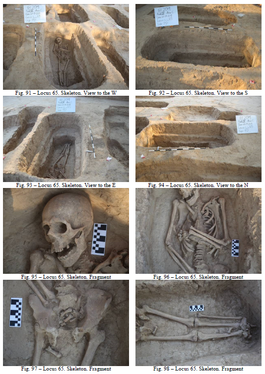
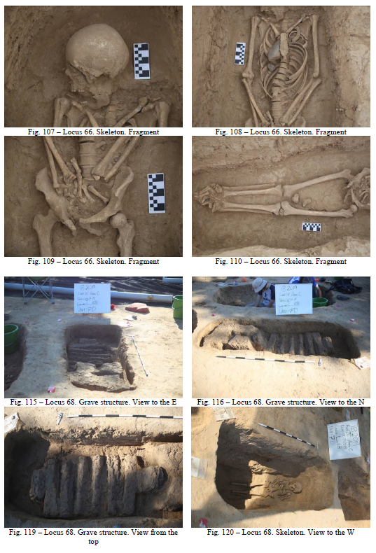
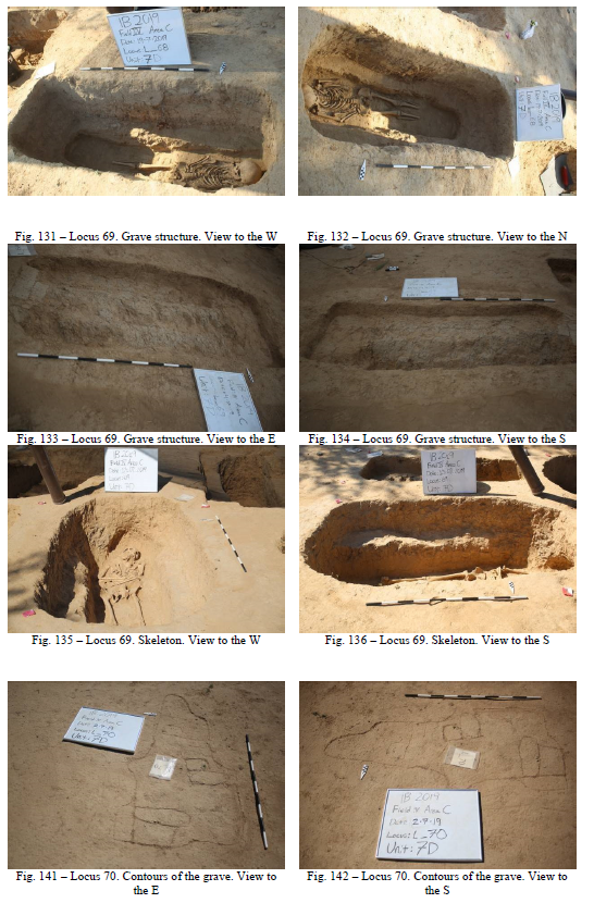
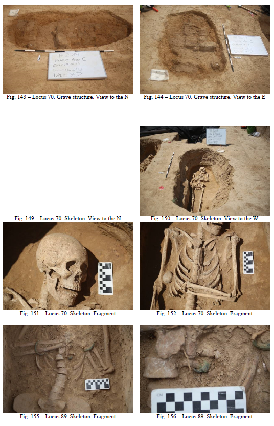
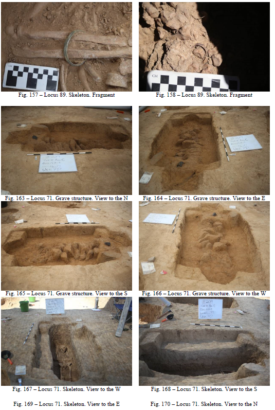
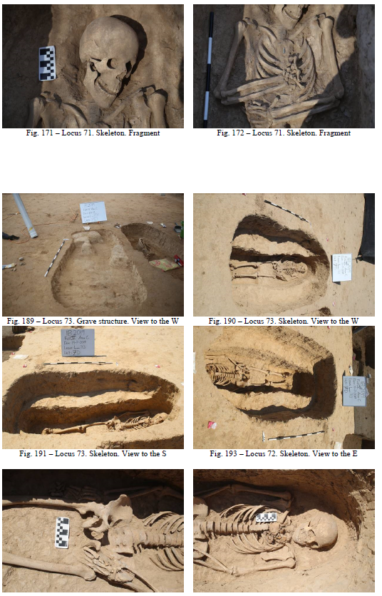
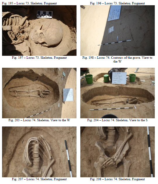
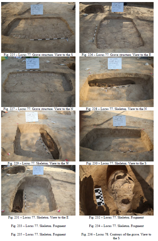
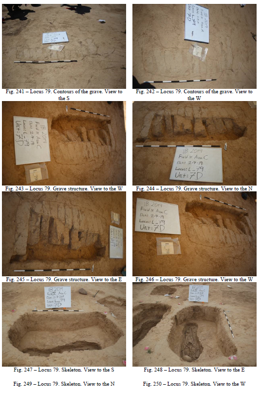
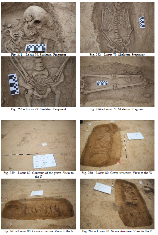
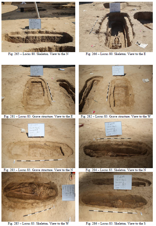
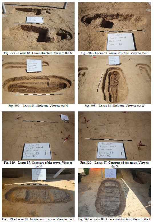
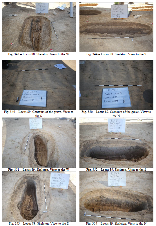
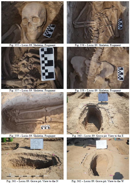
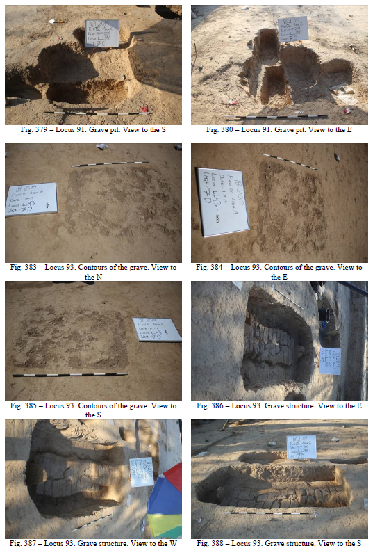
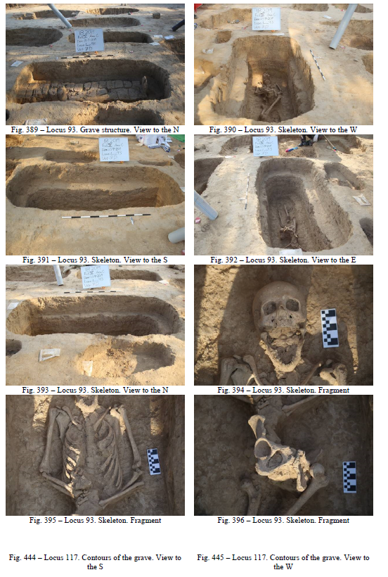
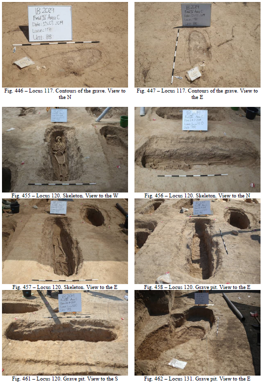
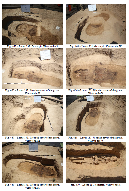
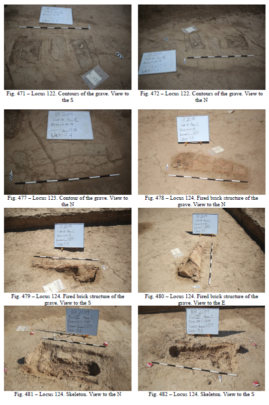
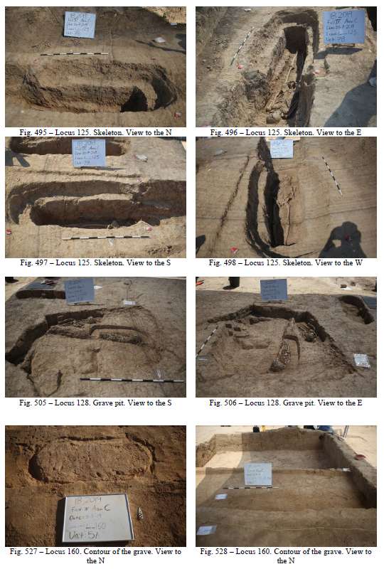
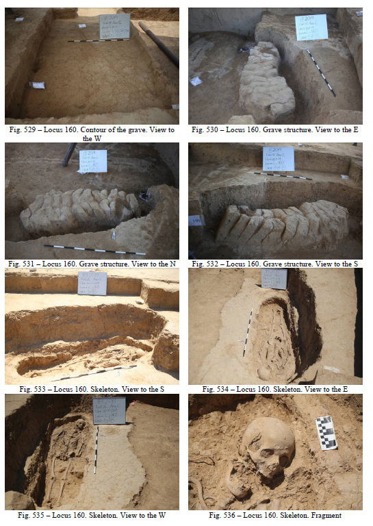
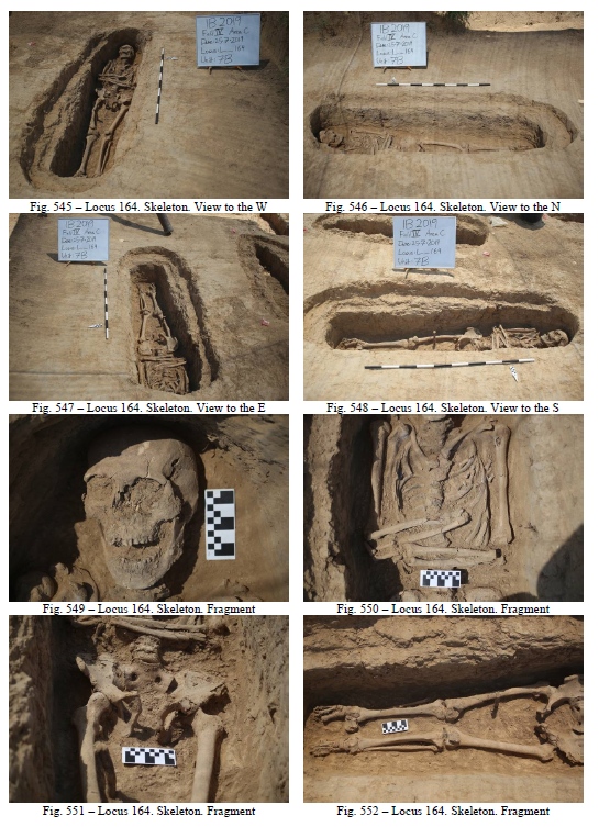
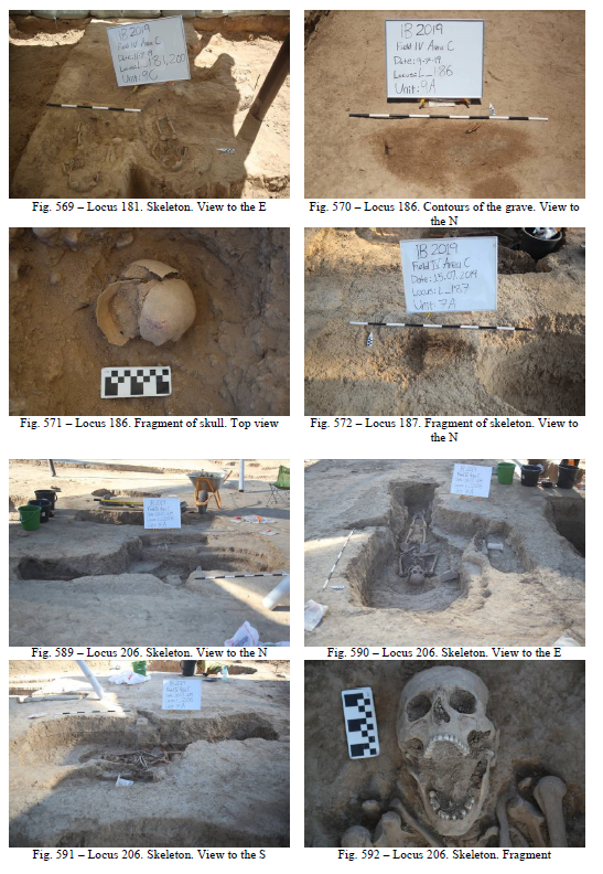
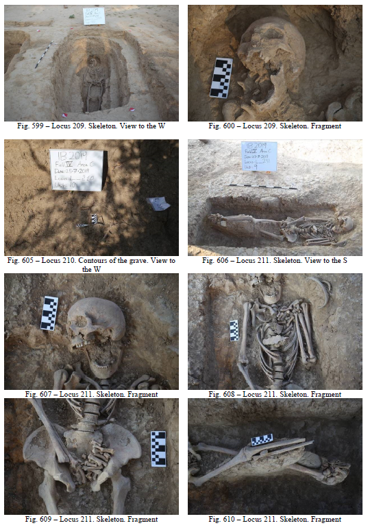
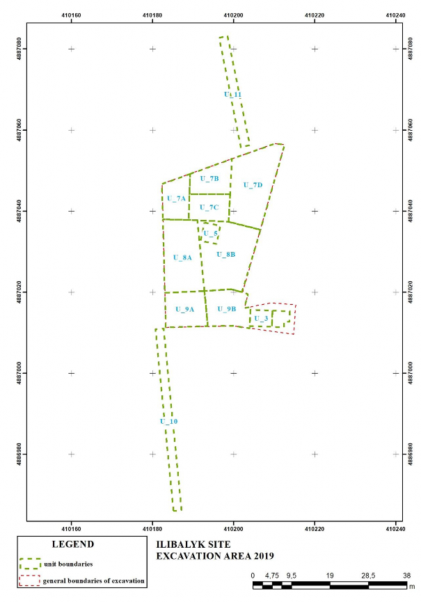
Fig. 1 – General view
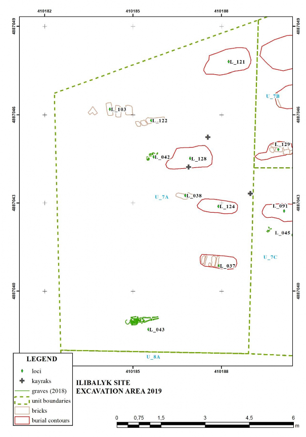
Fig. 2 – Unit 7A
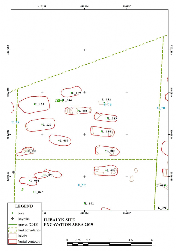
Fig. 3 – Unit 7B
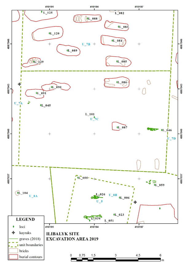
Fig. 4 – Unit 7C
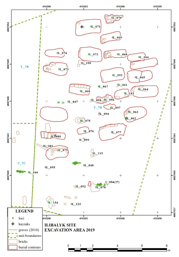
Fig. 5 – Unit 7D
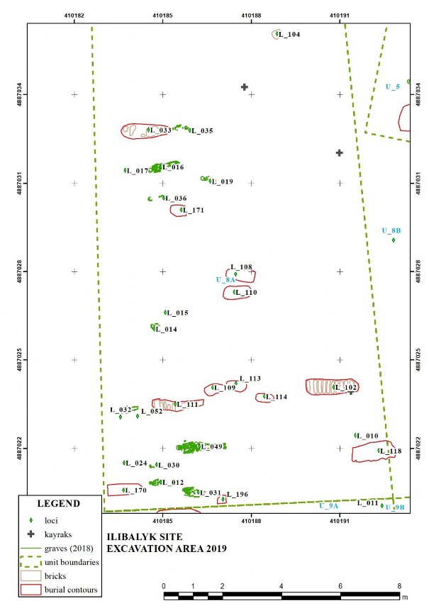
Fig. 6 – Unit 8A
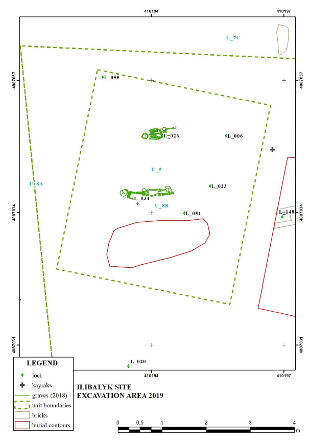
Fig. 7 – Unit 8B, 5
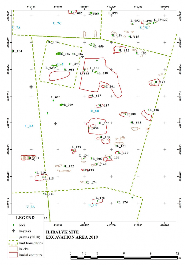
Fig. 8 – Unit 8B
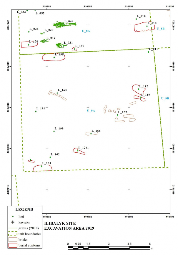
Fig. 9 – Unit 9A
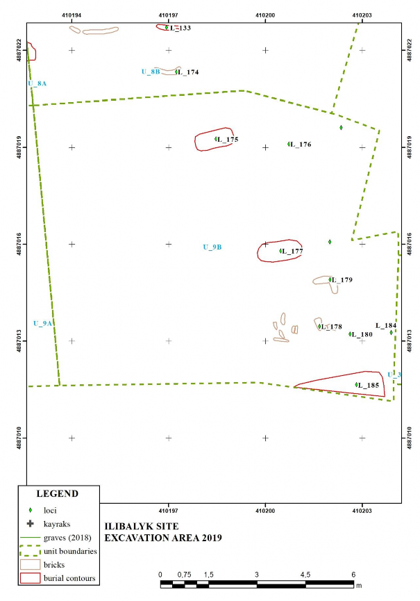
Fig. 10 – Unit 9B
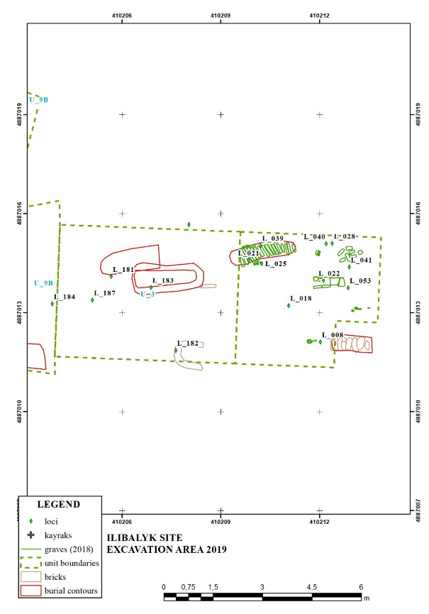
Fig. 11 – Unit 3
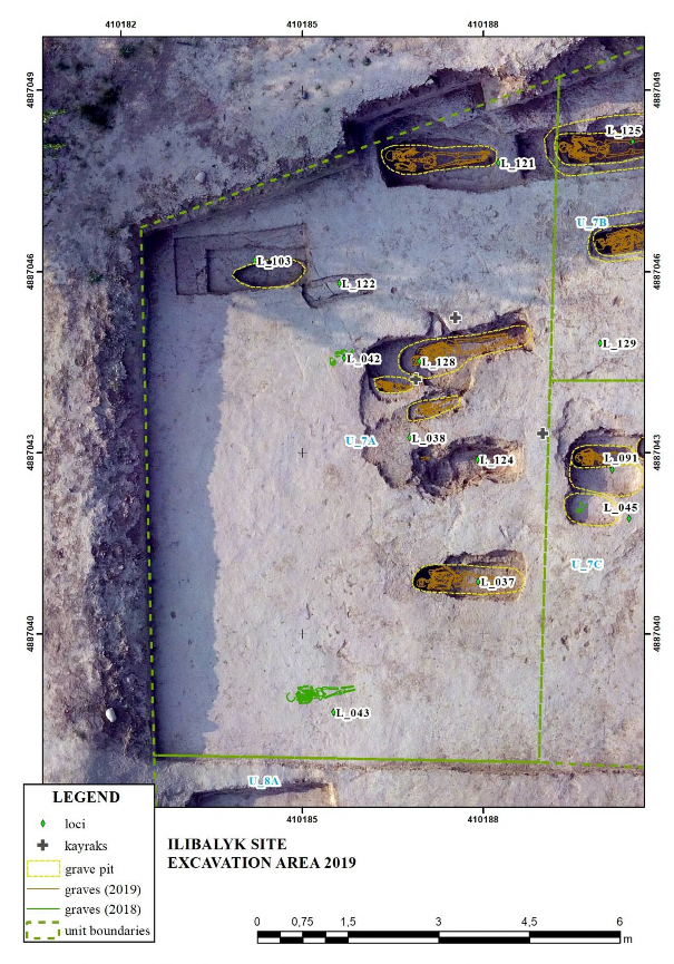
Fig. 12 – Unit 7A (ortophoto background)
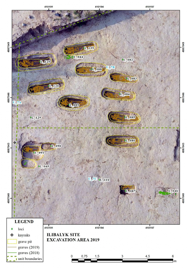
Fig. 13 – Unit 7B. 7C (ortophoto background)
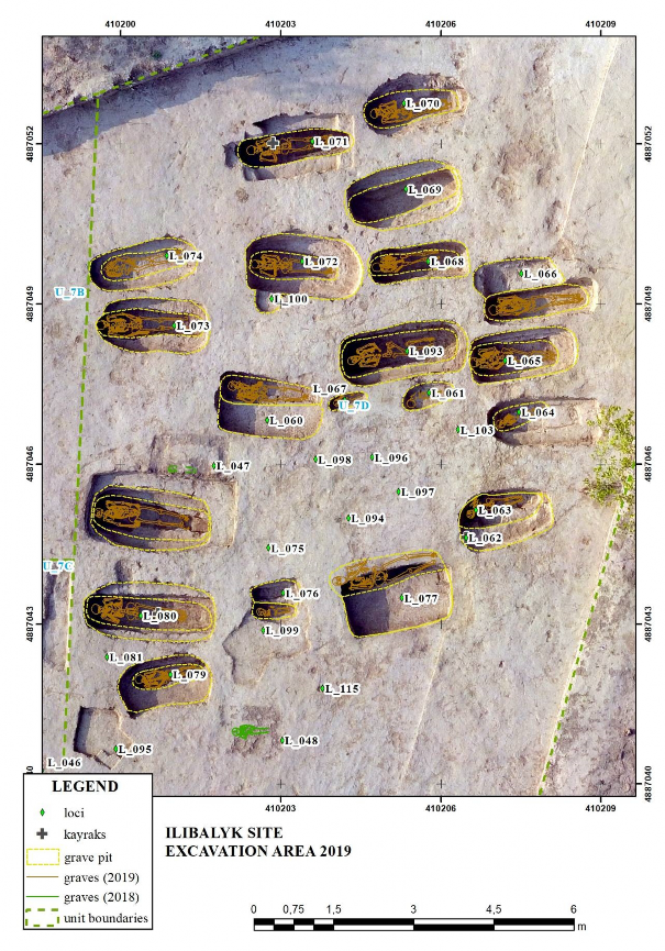
Fig. 14 – Unit 7D (ortophoto background)
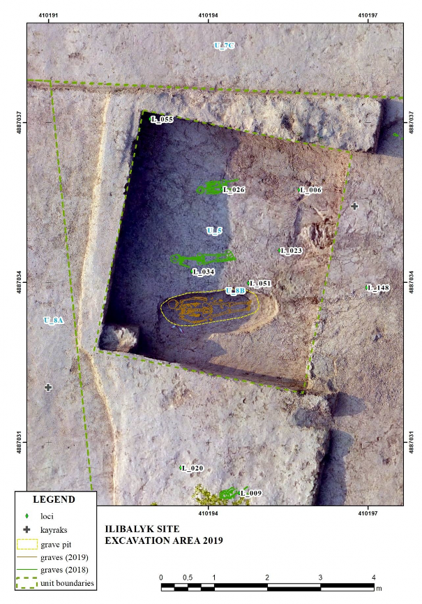
Fig. 15 – Unit 5 (ortophoto background)
Fig. 16 – Unit 9A (ortophoto background)
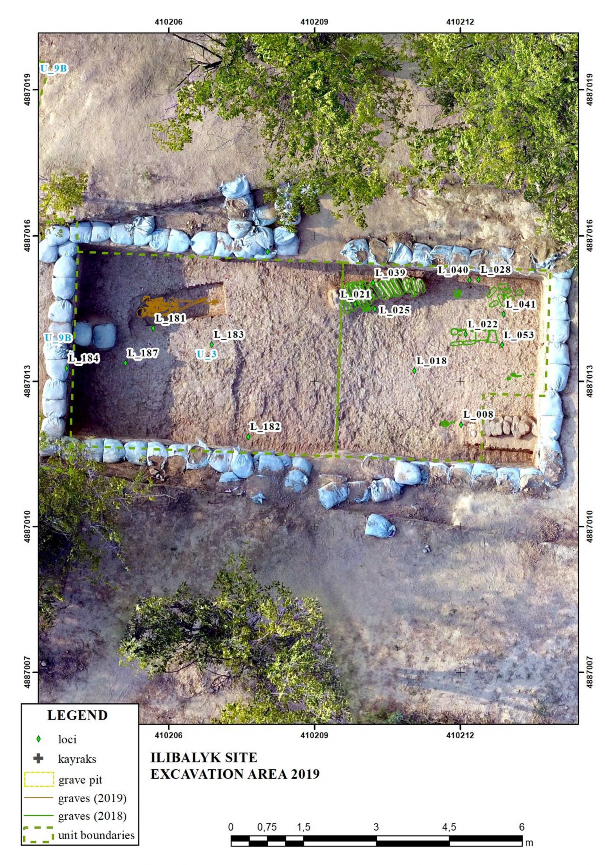
Fig. 17 – Unit 3 (ortophoto background)
Fig. 18 – Grave. Locus 60
Fig. 19 – Grave. Locus 61
For drawings of each grave locus, see unabridged report available upon request from the Society for the Exploration of Eurasia.
Natural Science Analysis Radio Carbon Analysis
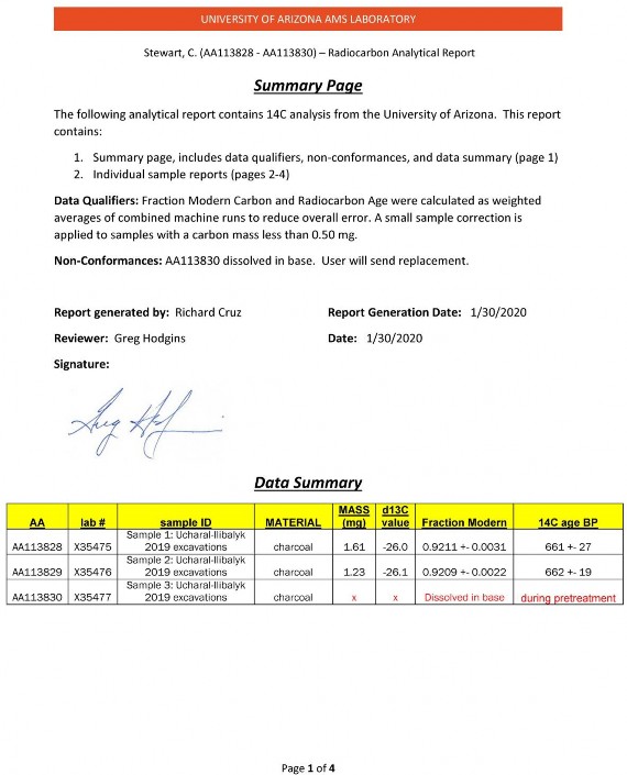
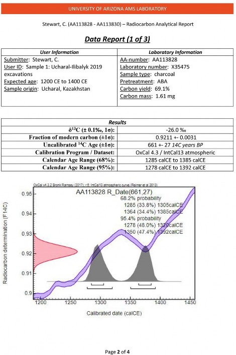
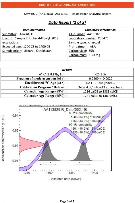
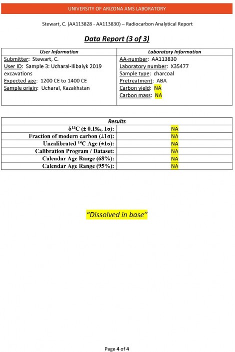
| copyright by The Society for the Exploration
of EurAsia| E-mail
| Home
| ![]()